IMAGES TAKEN NEAR TO
Geoffrey Avenue, ROMFORD, RM3 0YH
Introduction
This page details the photographs taken nearby to Geoffrey Avenue, RM3 0YH by members of the Geograph project.
The Geograph project started in 2005 with the aim of publishing, organising and preserving representative images for every square kilometre of Great Britain, Ireland and the Isle of Man.

There are currently over 7.5m images from over14,400 individuals and you can help contribute to the project by visiting https://www.geograph.org.uk
Image Map (Loading...)


Getting Data...Please wait
Leaflet Map data © OpenStreetMap
Images are licensed for reuse under creativecommons.org/licenses/by-sa/2.0
Notes
- Clicking on the map will re-center to the selected point.
- The higher the marker number, the further away the image location is from the centre of the postcode.
Image Listing (16 Images Found)
Images are licensed for reuse under creativecommons.org/licenses/by-sa/2.0
Image
Details
Distance
1
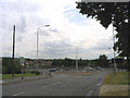
A12 Colchester Road, Harold Hill, Essex
Looking south from Petersfield Avenue
Image: © John Winfield
Taken: 4 Jul 2005
0.01 miles
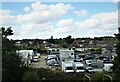
3
Industrial premises on Bates Road, Harold Wood, from the railway
Beyond the industrial estate, the residential areas of Harold Wood climb away from the camera.
Image: © Christopher Hilton
Taken: 18 Nov 2022
0.18 miles
4
Industrial premises on Bates Road, Harold Wood, from the railway
Beyond the industrial estate, the residential areas of Harold Wood climb away from the camera.
Image: © Christopher Hilton
Taken: 18 Nov 2022
0.18 miles
5
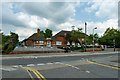
Harold Court Primary School
It is bedecked with bunting for the forthcoming school fete.
Image: © Robin Webster
Taken: 11 Jun 2011
0.19 miles
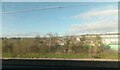
6
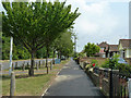
Path by houses fronting the A12
The housing along here was built in the days when it was quite normal for houses to open directly onto a major arterial road.
Image: © Robin Webster
Taken: 11 Jun 2011
0.19 miles
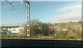
7
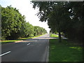
A12: London Loop crossing in Harold Park (2)
Walkers on the long-distance London Loop footpath take their lives into their own hands in crossing the dual carriageway A12 Colchester Road in Harold Park. This is the view from the crossing of the westbound carriageway looking east. The footpath goes through the dense hedge to the eastbound carriageway on the left. Fortunately the former Roman Road gives a good view back up the hill in this case.
Image: © Nigel Cox
Taken: 26 Aug 2013
0.21 miles
9
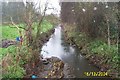
Ingrebourne River in Harold Park
Viewed looking southwestwards and downstream from the Harold Court Road bridge.
Image: © Nigel Cox
Taken: 16 Dec 2004
0.22 miles
10
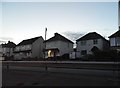
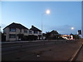
Houses on Colchester Road, Harold Park
Image: © David Howard
Taken: 1 May 2017
0.23 miles