IMAGES TAKEN NEAR TO
Oak Road, ROMFORD, RM3 0PS
Introduction
This page details the photographs taken nearby to Oak Road, RM3 0PS by members of the Geograph project.
The Geograph project started in 2005 with the aim of publishing, organising and preserving representative images for every square kilometre of Great Britain, Ireland and the Isle of Man.

There are currently over 7.5m images from over14,400 individuals and you can help contribute to the project by visiting https://www.geograph.org.uk
Image Map
Images are licensed for reuse under creativecommons.org/licenses/by-sa/2.0
Notes
- Clicking on the map will re-center to the selected point.
- The higher the marker number, the further away the image location is from the centre of the postcode.
Image Listing (48 Images Found)
Images are licensed for reuse under creativecommons.org/licenses/by-sa/2.0
Image
Details
Distance


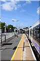
3
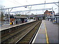
Harold Wood station
Harold Wood station was first opened on 1st December 1868 by the Great Eastern Railway on their main line. Two additional tracks which are normally used by fast services were provided in 1934 by the London & North Eastern Railway.
This view looks from the down slow line towards Romford and Liverpool Street. The fast lines are away to the left, beyond the metal fence. Beyond the footbridge in the distance is the bridge carrying Gubbins Lane over the lines.
Image: © Marathon
Taken: 31 Jan 2014
0.05 miles
4
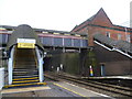
The footbridge at Harold Wood station
Harold Wood station was first opened on 1st December 1868 by the Great Eastern Railway on their main line. Two additional tracks which are normally used by fast services were provided in 1934 by the London & North Eastern Railway.
This view looks from the up slow line towards Romford and Liverpool Street. The fast lines are to the left, beyond the metal fence. Beyond the footbridge is the bridge carrying Gubbins Lane over the lines.
Image: © Marathon
Taken: 31 Jan 2014
0.05 miles
5
Harold Wood station
Harold Wood station was first opened on 1st December 1868 by the Great Eastern Railway on their main line. Two additional tracks which are normally used by fast services were provided in 1934 by the London & North Eastern Railway.
This view looks from the down slow line towards Romford and Liverpool Street. The fast lines are away to the left, beyond the metal fence. Beyond the footbridge is the bridge carrying Gubbins Lane over the lines.
Image: © Marathon
Taken: 31 Jan 2014
0.05 miles
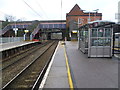
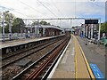
6
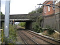
Railway south west from Harold Wood station
Looking towards London Liverpool Street from the end of platform 3, with the station entrance building on the right and the bridge carrying Gubbins Lane across the railway in the centre.
Image: © Richard Vince
Taken: 2 Sep 2023
0.05 miles
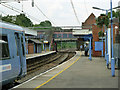
7
Harold Wood Station - Elizabeth Line
Platform 3 with a westbound train about to depart.
Image: © Trevor Harris
Taken: 27 May 2022
0.05 miles
8
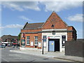
Harold Wood Station
This building is the ticket office and entrance to Harold Wood railway station.
Image: © Malc McDonald
Taken: 25 May 2013
0.05 miles
9
Harold Wood railway station, Greater London
Opened in 1868 by the Great Eastern Railway on its line from London Liverpool Street to Shenfield. It was rebuilt in 1934 when the line was quadrupled.
View south west towards Gidea Park and London. A new footbridge, platform railings and Transport for London signs have appeared since Image was taken from a similar position some seven years earlier.
Image: © Nigel Thompson
Taken: 15 Oct 2020
0.06 miles
10
On Harold Wood station
The limit of the London travel zone area on the Great Eastern line.
Image: © Robin Webster
Taken: 11 Jun 2011
0.07 miles