IMAGES TAKEN NEAR TO
Repton Avenue, ROMFORD, RM2 5LX
Introduction
This page details the photographs taken nearby to Repton Avenue, RM2 5LX by members of the Geograph project.
The Geograph project started in 2005 with the aim of publishing, organising and preserving representative images for every square kilometre of Great Britain, Ireland and the Isle of Man.

There are currently over 7.5m images from over14,400 individuals and you can help contribute to the project by visiting https://www.geograph.org.uk
Image Map
Images are licensed for reuse under creativecommons.org/licenses/by-sa/2.0
Notes
- Clicking on the map will re-center to the selected point.
- The higher the marker number, the further away the image location is from the centre of the postcode.
Image Listing (32 Images Found)
Images are licensed for reuse under creativecommons.org/licenses/by-sa/2.0
Image
Details
Distance
1
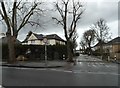
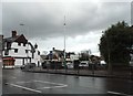
Main Road, Gidea Park
Havering Council do not like side roads and close them at will.
Image: © David Howard
Taken: 5 Mar 2017
0.02 miles
3
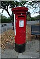
George V postbox on Main Road, Romford
Postbox No. RM2 163.
Image: © JThomas
Taken: 24 Aug 2022
0.05 miles
5
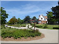
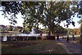
Entrance to Raphael Park
Raphael Park was formed from the western section of the landscaped grounds of the former Gidea Hall Estate. The lake was formed in the late 18th century above what is now known as Black's Bridge on Main Road. The bridge was required to span the widened Black's Canal. The canal was initially formed by damming and redirecting a tributary stream that fed the various water features of the earlier formal gardens of Gidea Hall. Where the canal passed through the estate of Gidea Hall it was widened to form a large serpentine lake. Black's Bridge is now Grade II Listed.
Sir Herbert Raphael purchased Gidea Hall and the Estate in 1897, and after that it was gradually divided and redeveloped. Around 1901 Sir Herbert offered some of the land from the Estate to Romford Urban District Council and this marked the beginnings of Raphael Park. It included the entrance of the old Estate, two entrance lodges, 15 acres of gardens and an ornamental canal and bridge. It was given for use as a public park for recreation and leisure "for the benefit of the townspeople".
Around 1902 a design competition was held for the park in keeping with the fashion of the age as 'the modern arcadia' The winning entry was produced by a Mr Ridge who was an assistant surveyor working for the Council. Raphael Park was officially opened on 2nd June 1904 by Sir Herbert and Lady Raphael with 5,000 people attending the event. This is the entrance from Main Road (A118).
There is a Friends of Raphael Park & Lodge Farm Park – see http://friendsofraphaelpark.org.uk/
Image: © Marathon
Taken: 10 May 2017
0.15 miles
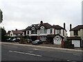
6
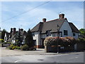
Houses in Gidea Park Conservation Area
After the opening of the station in 1910, an idealistic Arts and Crafts project named Romford Garden Suburb began here, with designs that won an architects’ competition. The homes were well-built, light and airy, and constructed in a variety of individual styles on the land attached to Gidea Hall.
A fuller history can be seen at http://hidden-london.com/gazetteer/gidea-park/ and https://en.wikipedia.org/wiki/Gidea_Park These houses are in Gidea Close.
Image: © Marathon
Taken: 10 May 2017
0.15 miles
7
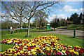
Amenity Horticulture in Raphael Park
A stunning splash of colour in Raphael Park Romford.
Image: © Glyn Baker
Taken: 10 Apr 2012
0.17 miles
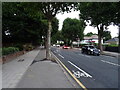
10
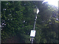
Victorian (or modern replica) lamp post on Heath Drive
Off Main Road in Gidea Park by the Richer Sounds electronics store and leading to the A12 just after Gallows Corner on the London-bound carriageway is a very pleasant side street dominated by the trees surrounding Romford Golf Course called Heath Drive, which is fittingly lit with these Victorian gas lanterns (or modern replicas of which). There are a couple of replacements with modern sodium lanterns further along, but apart from that, all over installations on the road are these. View taken looking north-northeast from Heath Drive at its junction with Main Road.
Image: © Robert Lamb
Taken: 7 Jun 2009
0.19 miles