IMAGES TAKEN NEAR TO
Stanley Avenue, ROMFORD, RM2 5DJ
Introduction
This page details the photographs taken nearby to Stanley Avenue, RM2 5DJ by members of the Geograph project.
The Geograph project started in 2005 with the aim of publishing, organising and preserving representative images for every square kilometre of Great Britain, Ireland and the Isle of Man.

There are currently over 7.5m images from over14,400 individuals and you can help contribute to the project by visiting https://www.geograph.org.uk
Image Map
Images are licensed for reuse under creativecommons.org/licenses/by-sa/2.0
Notes
- Clicking on the map will re-center to the selected point.
- The higher the marker number, the further away the image location is from the centre of the postcode.
Image Listing (9 Images Found)
Images are licensed for reuse under creativecommons.org/licenses/by-sa/2.0
Image
Details
Distance
1
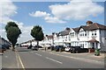
Carlton Road, Gidea Park
A very neat street of houses.
Image: © Des Blenkinsopp
Taken: 17 Jul 2024
0.12 miles
2
Gidea Park Railway Station, Gidea Park, Romford, Essex
This station is on the Liverpool Street - Southend line.
Image: © John Winfield
Taken: 5 Jul 2005
0.13 miles
3
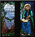
St Michael & All Angels, Main Road, Gidea Park - Window
Image: © John Salmon
Taken: 2 Mar 2005
0.13 miles
4
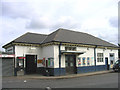
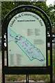
Conservation area information board, Gidea Park-1
Image: © Jim Osley
Taken: 20 Apr 2017
0.18 miles
5
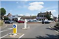
Gidea Motors, Balgores Road
The area nearby was developed before WW1 as Romford Garden Suburb. The single storey building on the corner doesn't look like it was designed for today's motor trade, and possibly dates from then.
Image: © Des Blenkinsopp
Taken: 17 Jul 2024
0.20 miles
6
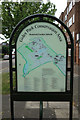
Conservation area information board, Gidea Park-2
Image: © Jim Osley
Taken: 20 Apr 2017
0.20 miles
7
Balgores Square, Gidea Park
Balgores Square is part of a development from the years just before the first world war when Romford Garden Suburb was one of many similar projects at that time aimed at creating new places to live that were actually quite nice.
Architects were commissioned to design suitable buildings and an exhibition was held in 1911.
The block on the corner here, with its arcaded shops at street level and two storeys of acommodation above is a part of that. Other places can be seen nearby.
Image
History on https://gpadcs.org/?page_id=132
Image: © Des Blenkinsopp
Taken: 17 Jul 2024
0.22 miles
8
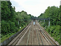
Railway west of Gidea Park
The outer lines are fanning out as Gidea Park has two wide island platforms.
Image: © Robin Webster
Taken: 11 Jun 2011
0.22 miles
9
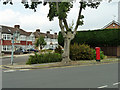
Pillar box at the corner
The corner is the junction of Carlton Road and Stanley Avenue.
Image: © Robin Webster
Taken: 11 Jun 2011
0.25 miles