IMAGES TAKEN NEAR TO
Stanley Avenue, ROMFORD, RM2 5BX
Introduction
This page details the photographs taken nearby to Stanley Avenue, RM2 5BX by members of the Geograph project.
The Geograph project started in 2005 with the aim of publishing, organising and preserving representative images for every square kilometre of Great Britain, Ireland and the Isle of Man.

There are currently over 7.5m images from over14,400 individuals and you can help contribute to the project by visiting https://www.geograph.org.uk
Image Map
Images are licensed for reuse under creativecommons.org/licenses/by-sa/2.0
Notes
- Clicking on the map will re-center to the selected point.
- The higher the marker number, the further away the image location is from the centre of the postcode.
Image Listing (13 Images Found)
Images are licensed for reuse under creativecommons.org/licenses/by-sa/2.0
Image
Details
Distance
1
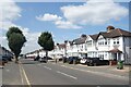
Carlton Road, Gidea Park
A very neat street of houses.
Image: © Des Blenkinsopp
Taken: 17 Jul 2024
0.16 miles
2
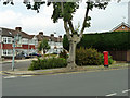
Pillar box at the corner
The corner is the junction of Carlton Road and Stanley Avenue.
Image: © Robin Webster
Taken: 11 Jun 2011
0.18 miles
3
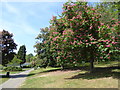
Lodge Farm Park
In 1918 the owners of the Estate of Lodge Farm who were Roger Reede's Charity agreed to lease the farm and premises of Lodge Farm for 14 years to the Agent of the High Grade Dairy Company. The land was to be used for farming only. On 10th March 1927 the owners agreed to sell several parcels of land to Romford Urban District Council for £1,350. The land to be sold stretched from a point at the north known as Black's Bridge to Carlton Road in the south.
Some time after, the Council started to use the land as a rubbish tip and when the tipping was completed the land was left uncultivated for some time to allow it to settle. In 1961 a comprehensive layout for the park was prepared and agreed by the Council and this is as seen today with two bowling greens and a children's playground. The cost was £42,000 and it was completed in 1962. A miniature railway is also in the process of being installed - see http://www.romfordrecorder.co.uk/news/railway-fun-for-families-in-lodge-farm-park-gidea-park-1-4522114
There is a Friends of Raphael Park & Lodge Farm Park - see http://friendsofraphaelpark.org.uk/
Image: © Marathon
Taken: 10 May 2017
0.19 miles
5
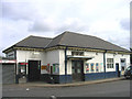
Gidea Park Railway Station, Gidea Park, Romford, Essex
This station is on the Liverpool Street - Southend line.
Image: © John Winfield
Taken: 5 Jul 2005
0.20 miles
6
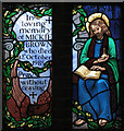
St Michael & All Angels, Main Road, Gidea Park - Window
Image: © John Salmon
Taken: 2 Mar 2005
0.20 miles
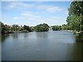
7
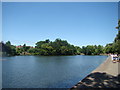
View of the lake in Raphael Park, looking downstream
Looking south-southeast.
Image: © Robert Lamb
Taken: 4 Jul 2010
0.22 miles
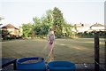
8
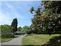
Path in Lodge Farm Park
In 1918 the owners of the Estate of Lodge Farm who were Roger Reede's Charity agreed to lease the farm and premises of Lodge Farm for 14 years to the Agent of the High Grade Dairy Company. The land was to be used for farming only. On 10th March 1927 the owners agreed to sell several parcels of land to Romford Urban District Council for £1,350. The land to be sold stretched from a point at the north known as Black's Bridge to Carlton Road in the south.
Some time after, the Council started to use the land as a rubbish tip and when the tipping was completed the land was left uncultivated for some time to allow it to settle. In 1961 a comprehensive layout for the park was prepared and agreed by the Council and this is as seen today with two bowling greens and a children's playground. The cost was £42,000 and it was completed in 1962. A miniature railway is also in the process of being installed - see http://www.romfordrecorder.co.uk/news/railway-fun-for-families-in-lodge-farm-park-gidea-park-1-4522114
There is a Friends of Raphael Park & Lodge Farm Park - see http://friendsofraphaelpark.org.uk/
Image: © Marathon
Taken: 10 May 2017
0.23 miles
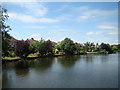
9
Fountain in the lake in Raphael Park, taken from Main Road bridge
Looking south.
Image: © Robert Lamb
Taken: 4 Jul 2010
0.23 miles
10
View of houses on Lake Rise from the Main Road bridge
Looking southeast.
Image: © Robert Lamb
Taken: 4 Jul 2010
0.23 miles