IMAGES TAKEN NEAR TO
Gardners Way, Oliver Road, GRAYS, RM20 3AA
Introduction
This page details the photographs taken nearby to Gardners Way, Oliver Road, RM20 3AA by members of the Geograph project.
The Geograph project started in 2005 with the aim of publishing, organising and preserving representative images for every square kilometre of Great Britain, Ireland and the Isle of Man.

There are currently over 7.5m images from over14,400 individuals and you can help contribute to the project by visiting https://www.geograph.org.uk
Image Map
Images are licensed for reuse under creativecommons.org/licenses/by-sa/2.0
Notes
- Clicking on the map will re-center to the selected point.
- The higher the marker number, the further away the image location is from the centre of the postcode.
Image Listing (15 Images Found)
Images are licensed for reuse under creativecommons.org/licenses/by-sa/2.0
Image
Details
Distance
1

Royal Mail Distribution Centre, West Thurrock
On Oliver Road.
Image: © David Anstiss
Taken: 7 Nov 2012
0.03 miles
2

A1090 Oliver Road
Until recently this was a minor road. However a distribution depot has opened up behind the photographer that sounds as if it is run by legendary tough women.
Image: © Glyn Baker
Taken: 5 May 2020
0.06 miles

4

Oliver Road, West Thurrock
The Queen Elizabeth Bridge can be seen ahead in the distance.
Image: © Trevor Harris
Taken: 10 Mar 2015
0.18 miles
5
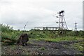
Derelict land , West Thurrock
All that remains of a works building.
Image: © N Chadwick
Taken: 18 Jun 2011
0.19 miles
6

Waiting For A Bioblitz
Essex Wildlife Trust staff are waiting at Image for a small army of volunteers to arrive to record as many species as they can during the day. Often common species go unrecorded. The technique of the Bioblitz https://en.wikipedia.org/wiki/BioBlitz uses citizen scientists to get as comprehensive picture of the habitat as possible.
Image: © Glyn Baker
Taken: 29 Jun 2022
0.21 miles
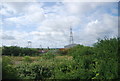
7
Oliver Road Lagoons Nature Reserve
Oliver Road Reserve is owned by The Land Trust https://thelandtrust.org.uk/space/oliver-road-lagoons/ but since 2018 has been managed by
Essex Wildlife Trust https://www.essexwt.org.uk/. The 40ha site is that of a former coal fired power station demolished around 1997. The land contaminated with fly ash became secondary birch woodland with little biodiversity. The clearance of many of the trees has led to significant improvement in this. 59 “Red List” species have been recorded on the site as well as a further 27 nationally scarce species. The reserve is particularly good for invertebrates and includes the largest intertidal mudflats in the inner Thames area. The reserve is closed to the public due to the contaminated nature of the soil. However you could join the Wednesday work party https://www.essexwt.org.uk/volunteering-opportunities/work-party-volunteers-oliver-road-lagoons To continue on a tour of Wildlife Trust sites in Essex visit Image
Image: © Glyn Baker
Taken: 29 Jun 2022
0.21 miles
8

Vetch at Oliver Rd Lagoons
An attractive native plant on Image
Image: © Glyn Baker
Taken: 29 Jun 2022
0.22 miles
9
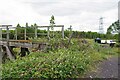
Old Bridge at Oliver Road
This decaying bridge is on Image a 40ha site managed by Essex Wildlife Trust https://www.essexwt.org.uk/ in the background you can see the birch woodland that once colonised this brownfield site. Clearance of the trees has created some nationally important habitat. 59 Red list species have been recorded on site.
Image: © Glyn Baker
Taken: 29 Jun 2022
0.22 miles