IMAGES TAKEN NEAR TO
Water Lane, PURFLEET-ON-THAMES, RM19 1GS
Introduction
This page details the photographs taken nearby to Water Lane, RM19 1GS by members of the Geograph project.
The Geograph project started in 2005 with the aim of publishing, organising and preserving representative images for every square kilometre of Great Britain, Ireland and the Isle of Man.

There are currently over 7.5m images from over14,400 individuals and you can help contribute to the project by visiting https://www.geograph.org.uk
Image Map
Images are licensed for reuse under creativecommons.org/licenses/by-sa/2.0
Notes
- Clicking on the map will re-center to the selected point.
- The higher the marker number, the further away the image location is from the centre of the postcode.
Image Listing (18 Images Found)
Images are licensed for reuse under creativecommons.org/licenses/by-sa/2.0
Image
Details
Distance
1
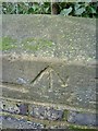
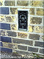
Benchmark on railway bridge in Tank Lane
Ordnance Survey rivet benchmark described on the Bench Mark Database at http://www.bench-marks.org.uk/bm36057
Image: © Roger Templeman
Taken: 21 Nov 2010
0.09 miles

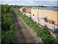
3

Railway line north of Purfleet station
Image: © Mike Pennington
Taken: 22 Oct 2022
0.13 miles
5
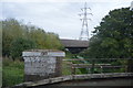
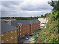
Purfleet: railway & new housing
Taken from the Tank Lane overbridge and looking towards Purfleet station with the new Bellway housing development to the right.
Image: © Nigel Cox
Taken: 11 Aug 2006
0.17 miles
6

Tank farm, Purfleet
Built in an old chalk quarry, these tanks have now gone. The central chimney in the distance is for the Thames Board Mills boilers, the power station at right is Littlebrook. This view is before the QE2 bridge was built - only the tunnels connect the two ends of the M25.
Image: © Robin Webster
Taken: Unknown
0.17 miles
7
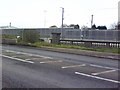
Arterial Road, Bridge over Mardyke and Channel Tunnel railway line
Image: © Roger Templeman
Taken: 21 Nov 2010
0.18 miles
8
Flush bracket serial number S0875 on Purfleet Primary School
Ordnance Survey flush bracket benchmark described on the Bench Mark Database at http://www.bench-marks.org.uk/bm10926
Image: © Roger Templeman
Taken: 21 Nov 2010
0.18 miles
9
Purfleet: Church Hollow
This new housing development, viewed from Tank Lane, is in a former chalk quarry, although Streetmap currently shows it as an oil depot, suggesting that this is at least its second major change of use.
Image: © Nigel Cox
Taken: 11 Aug 2006
0.20 miles