IMAGES TAKEN NEAR TO
Colne Court, TILBURY, RM18 8RE
Introduction
This page details the photographs taken nearby to Colne Court, RM18 8RE by members of the Geograph project.
The Geograph project started in 2005 with the aim of publishing, organising and preserving representative images for every square kilometre of Great Britain, Ireland and the Isle of Man.

There are currently over 7.5m images from over14,400 individuals and you can help contribute to the project by visiting https://www.geograph.org.uk
Image Map
Images are licensed for reuse under creativecommons.org/licenses/by-sa/2.0
Notes
- Clicking on the map will re-center to the selected point.
- The higher the marker number, the further away the image location is from the centre of the postcode.
Image Listing (11 Images Found)
Images are licensed for reuse under creativecommons.org/licenses/by-sa/2.0
Image
Details
Distance
1
The Edge of Town
An unusual feature of the pedestrianised streets in the area is they are named after rivers with no title such as street road or drive. This is the edge of “Welland”
Image: © Glyn Baker
Taken: 13 Aug 2005
0.11 miles
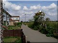
2
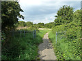
Footpath to East Tilbury
This is the last section of a path leading from the sea wall path near the River Thames and Mucking flats.
This path leads beside a field, before passing a small town park.
Image: © David Anstiss
Taken: 16 Oct 2012
0.15 miles
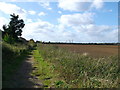
3
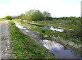
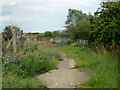
Footpaths from East Tilbury to sea wall
There seem to be two parallel competing footpaths here separated by a flooded area! Other walkers said they followed the path on the left rather than the path beside the fence on the right.
Image: © David Kemp
Taken: 5 May 2021
0.16 miles
4
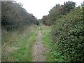
East Tilbury: Footpath near the former Gobions farm
Gobions farm has gone. This view was taken looking back towards East Tilbury.
Image: © Nigel Cox
Taken: 20 Oct 2016
0.17 miles
5
Footpath from East Tilbury station to sea wall
The path curves round through the site of Gobions Farm, all of the several buildings have now gone.
Image: © Robin Webster
Taken: 10 Jul 2011
0.17 miles
6
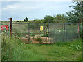
Diversion on footpath 147
The gates ahead bar any further progress on the original line, the red sign points to the new route to the right. The diversion must have been made a long time ago - the area beyond is of landfill and looks very established. The small yellow sign is a public notice concerning a sought-for extension of the time allowed for "restoration" of the site. How an area of low-lying marsh can be restored from a rather high area of landfill without removing what was dumped is a puzzle.
Image: © Robin Webster
Taken: 10 Jul 2011
0.19 miles
7
Gate on footpath to Mucking Flats
This fence lined path leads from Princess Margaret Road,East Tilbury towards the sea wall path near the River Thames. Beyond the tall shrubs/trees (on the left) is Mucking Marshes, which is also part of a council rubbish tip.
Beyond the tall shrubs (on the right) is a former quarry.
Image: © David Anstiss
Taken: 16 Oct 2012
0.19 miles
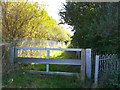
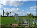
8
Footpath from sea wall to East Tilbury station
Footpath 147 has an anti-motorbike barrier ahead.
Image: © Robin Webster
Taken: 10 Jul 2011
0.19 miles
9
Diversion on footpath 147
The gates ahead bar any further progress on the original line, the red sign points to the new route to the right. The diversion must have been made a long time ago - the area beyond is of landfill and looks very established. The small yellow sign is a public notice concerning a sought-for extension of the time allowed for "restoration" of the site. How an area of low-lying marsh can be restored from a rather high area of landfill without removing what was dumped is a puzzle.
Image: © Robin Webster
Taken: 10 Jul 2011
0.19 miles
10
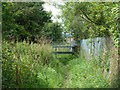
Path into Gobions Park, East Tilbury
This small council managed park is near the housing estates of East Tilbury.
Image: © David Anstiss
Taken: 16 Oct 2012
0.24 miles