IMAGES TAKEN NEAR TO
Ferry Road, TILBURY, RM18 7NH
Introduction
This page details the photographs taken nearby to Ferry Road, RM18 7NH by members of the Geograph project.
The Geograph project started in 2005 with the aim of publishing, organising and preserving representative images for every square kilometre of Great Britain, Ireland and the Isle of Man.

There are currently over 7.5m images from over14,400 individuals and you can help contribute to the project by visiting https://www.geograph.org.uk
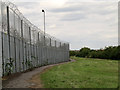
Image Map
Images are licensed for reuse under creativecommons.org/licenses/by-sa/2.0
Notes
- Clicking on the map will re-center to the selected point.
- The higher the marker number, the further away the image location is from the centre of the postcode.
Image Listing (64 Images Found)
Images are licensed for reuse under creativecommons.org/licenses/by-sa/2.0
Image
Details
Distance
1
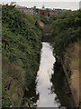
Drainage ditch on West Tilbury Marsh
Was it coincidence or deliberate planning that the line of this ditch heads directly towards the spire of St George’s church in Gravesend, the other side of the river? In the middle distance is the pumping station whose wet well is seen in Image
Image: © Stephen Craven
Taken: 10 Aug 2013
0.06 miles
2

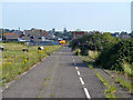
Outskirts of Tilbury
The start of the urban speed limit on the new alignment of Fort Road (for the old alignment, see Image).
Image: © Stephen Craven
Taken: 10 Aug 2013
0.06 miles
3
Remains of a jetty
A few rotting timber posts are all that remains of some structure, probably a small jetty, on a drainage ditch parallel to the outer moat of Tilbury Fort.
Image: © Stephen Craven
Taken: 10 Aug 2013
0.07 miles
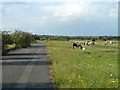
4
Disused part of Fort Road, Tilbury
This part has been bypassed by a new route. The church directly in line with the road is St. George's, Gravesend.
Image: © Robin Webster
Taken: 10 Jul 2011
0.09 miles
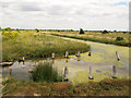
5
Disused part of Fort Road, Tilbury
This part has been bypassed by a new route. There are a great many horses on the common land and associated pasture around here.
Image: © Robin Webster
Taken: 10 Jul 2011
0.09 miles
6
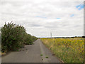
Footpath no 144, Tilbury
The footpath has been diverted around the edge of a new industrial estate since the 1998 edition of the Explorer map was published, which showed it heading directly north from the Tilbury Ferry landing stage.
Image: © Stephen Craven
Taken: 10 Aug 2013
0.11 miles
7

Turbines, little and large
The three small wind turbines in this view (only one of which was operating) serve a new business park; the larger turbine is one of four at Tilbury Port beyond. Viewed from the north-west bastion of Tilbury Fort.
Image: © Stephen Craven
Taken: 10 Aug 2013
0.12 miles
8
Fort Road (abandoned)
This is shown on my Explorer map (1998 edition) as a public road, called Fort Road (as it leads to, or in this direction, away from Tilbury Fort). By 2013 it had been abandoned, superseded by the spine road of a new business park nearby Image and is shown on contemporary maps as a public footpath.
Image: © Stephen Craven
Taken: 10 Aug 2013
0.12 miles
9
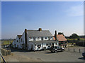
Worlds End Public House, Tilbury Riverside, Essex
Image: © John Winfield
Taken: 13 Jul 2005
0.14 miles
10
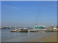
Tilbury Ferry Dock, Tilbury, Essex
Dock for the Tilbury-Gravesend passenger ferry.
Image: © John Winfield
Taken: 13 Jul 2005
0.14 miles