IMAGES TAKEN NEAR TO
Ferry Road, TILBURY, RM18 7NG
Introduction
This page details the photographs taken nearby to Ferry Road, RM18 7NG by members of the Geograph project.
The Geograph project started in 2005 with the aim of publishing, organising and preserving representative images for every square kilometre of Great Britain, Ireland and the Isle of Man.

There are currently over 7.5m images from over14,400 individuals and you can help contribute to the project by visiting https://www.geograph.org.uk
Image Map
Images are licensed for reuse under creativecommons.org/licenses/by-sa/2.0
Notes
- Clicking on the map will re-center to the selected point.
- The higher the marker number, the further away the image location is from the centre of the postcode.
Image Listing (148 Images Found)
Images are licensed for reuse under creativecommons.org/licenses/by-sa/2.0
Image
Details
Distance
1
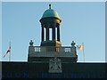
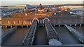
Detail of the roof of the London International Passenger Terminal, Tilbury
A close-up of the roof detail of Image
As seen from Ferry Road.
Image: © David Anstiss
Taken: 16 Oct 2012
0.00 miles
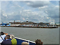
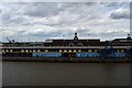
3
London International Cruise Terminal, Tilbury
In 1916, Tilbury became the only port in the Port of London Authority to serve cruise liners when it opened berths specifically for the P&O line within the dock complex. With the need for expanded facilities, a large new passenger landing stage was constructed in the Thames jointly by the PLA and the London Midland and Scottish Railway, with rail connections. It was opened in May 1930 by Ramsay MacDonald.
Tilbury operated as London's passenger liner terminal until the 1960s. For many people, Tilbury was their point of emigration to Australia under an assisted passage scheme established and operated by the Australian Government. It was also a port of entry for many immigrants; among them, a large group of West Indians on HMT Empire Windrush in 1948 https://en.wikipedia.org/wiki/HMT_Empire_Windrush .
The passenger landing stage was reopened by the Port of Tilbury group as the London Cruise Terminal in 1995 although it is no longer served by the railway.
Image: © David Dixon
Taken: 11 Nov 2018
0.01 miles
4
London International Cruise Terminal Building at Tilbury
In 1916, Tilbury became the only port in the Port of London Authority to serve cruise liners when it opened berths specifically for the P&O line within the dock complex. With the need for expanded facilities, a large new passenger landing stage was constructed in the Thames jointly by the PLA and the London Midland and Scottish Railway, with rail connections. It was opened in May 1930 by Ramsay MacDonald.
Tilbury operated as London's passenger liner terminal until the 1960s. For many people, Tilbury was their point of emigration to Australia under an assisted passage scheme established and operated by the Australian Government. It was also a port of entry for many immigrants; among them, a large group of West Indians on HMT Empire Windrush in 1948 https://en.wikipedia.org/wiki/HMT_Empire_Windrush .
The passenger landing stage was reopened by the Port of Tilbury group as the London Cruise Terminal in 1995 although it is no longer served by the railway.
Image: © David Dixon
Taken: 11 Nov 2018
0.01 miles
5
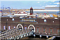
Tilbury Cruise Terminal and former Tilbury Riverside station
The large building on the left is the cruise terminal, that on the right the former station. The landing stage is used also by the Tilbury - Gravesend passenger ferry. Before the Purfleet - Dartford tunnel, it was a vehicle ferry, hence the heavy construction of the near hinging bridge connecting the floating landing stage to the shore. The cruise terminal dealt formerly with passenger liners, when serious travel by sea was usual. It was a PLA and LMS Railway joint venture, London passengers using boat trains to and from St. Pancras originally. Later, after electrification, the dwindling trade used Fenchurch Street, using special multiple units with large luggage capacity.
Image: © Robin Webster
Taken: 30 Jun 2011
0.02 miles
6
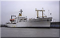
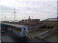
Training Ship Empire State (VI), Tilbury Cruise Terminal
Converted steam turbine powered cargo vessel used as a training ship by the State University of New York. Photographed on a misty morning from the Gravesend ferry (the five minute ferry). We had just been on board to see the machinery spaces and bridge. Very peaceful standing on the bridge overlooking the river.
Image: © Chris Allen
Taken: 16 Jun 2000
0.03 miles
7
London International Cruise Terminal, Tilbury
From the deck of the MV Magellan.
Image: © Mike Pennington
Taken: 7 Jan 2018
0.03 miles
8
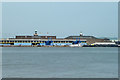
Tilbury Cruise Terminal and former Tilbury Riverside station
The large building on the left is the cruise terminal, that on the right the former station. The landing stage is used also by the Tilbury - Gravesend passenger ferry and before the Purfleet - Dartford tunnel was built, the vehicle ferry. The cruise terminal dealt formerly with passenger liners, when serious travel by sea was usual. It was a PLA and LMS Railway joint venture, London passengers using boat trains to and from St. Pancras originally. Later, after electrification, the dwindling trade used Fenchurch Street, using special multiple units with large luggage capacity.
Image: © Robin Webster
Taken: 27 Jun 2011
0.03 miles
9
London International Cruise Terminal
From the boat deck of the MV Columbus
Image: © John Myers
Taken: 24 Aug 2018
0.03 miles
10
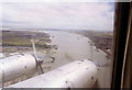
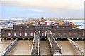
Tilbury docks from the air
The large jetty in the centre of this view is Tilbury passenger terminal. The docks are just before it, Tilbury fort just beyond and Tilbury B power station's chimneys are in the distance.
This was taken from a Vickers Viscount during a scenic flight in 1996 to commemorate the type's retirement from commercial service.
Image: © Stephen Williams
Taken: 29 Jul 1996
0.04 miles