IMAGES TAKEN NEAR TO
Fort Road, TILBURY, RM18 7ND
Introduction
This page details the photographs taken nearby to Fort Road, RM18 7ND by members of the Geograph project.
The Geograph project started in 2005 with the aim of publishing, organising and preserving representative images for every square kilometre of Great Britain, Ireland and the Isle of Man.

There are currently over 7.5m images from over14,400 individuals and you can help contribute to the project by visiting https://www.geograph.org.uk
Image Map (Loading...)


Getting Data...Please wait
Leaflet Map data © OpenStreetMap
Images are licensed for reuse under creativecommons.org/licenses/by-sa/2.0
Notes
- Clicking on the map will re-center to the selected point.
- The higher the marker number, the further away the image location is from the centre of the postcode.
Image Listing (153 Images Found)
Images are licensed for reuse under creativecommons.org/licenses/by-sa/2.0
Image
Details
Distance
1
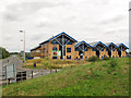
Riverside Business Centre, Tilbury
A new development close to the container terminal and alongside a new access road following the line of a former public footpath.
Image: © Stephen Craven
Taken: 10 Aug 2013
0.01 miles
2
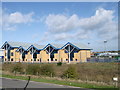
Riverside Business Centre, Tilbury
On Fort Road.
Image: © David Anstiss
Taken: 16 Oct 2012
0.01 miles
3

Turbines, little and large
The three small wind turbines in this view (only one of which was operating) serve a new business park; the larger turbine is one of four at Tilbury Port beyond. Viewed from the north-west bastion of Tilbury Fort.
Image: © Stephen Craven
Taken: 10 Aug 2013
0.04 miles
4
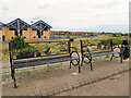
Decorative benches
A pair of metal benches with unique shipping-themed decorative backs, on the riverside walk at Tilbury.
Image: © Stephen Craven
Taken: 10 Aug 2013
0.05 miles
5
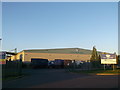
Portside Logistics Centre, Tilbury
Large warehouse surrounded in large multi-coloured containers on Ferry Road.
Image: © David Anstiss
Taken: 16 Oct 2012
0.09 miles
6
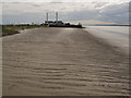
Tilbury Mudflats
A very gently sloping bed to the north side of the Thames at Tilbury, with the power station in the distance. At this time the power station was non-operational, having closed as a coal-fired station, been converted to biomass operation and awaiting operating consent. Link: http://www.rwe.com/web/cms/en/1763234/rwe-npower/about-us/our-businesses/power-generation/tilbury/tilbury-biomass-power-station/
Image: © Stephen Craven
Taken: 10 Aug 2013
0.09 miles
7
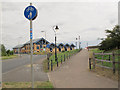
Shared use path
This cycle and pedestrian path leads from Tilbury ferry terminal to the old fort nearby.
Image: © Stephen Craven
Taken: 10 Aug 2013
0.10 miles
8
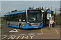
Ensignbus at Tilbury Ferry
When Tilbury Riverside station closed in 1992 a bus service was provided to link Tilbury Town station with the ferry. The latest operator to provide this service is Ensignbus whose AD Enviro200 711 awaits the next ferry arrival.
Image: © David Kemp
Taken: 17 Jul 2017
0.10 miles
9
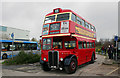
Vintage 3RT3/4 RT-type bus at Tilbury Ferry
Experts will immediately recognise this shot of RT 1431 as one of 120 buses with non-standard Cravens bodies delivered to London Transport in 1948/9. By the mid-1950s LT found itself with a surplus of vehicles due to falling traffic and it was the non-standard 'Craven RTs' that first got the chop when they were sold off to other operators in 1956. 1431 is one of three preserved examples and is seen here awaiting action at the Ensignbus annual running day in Thurrock.
Image: © David Kemp
Taken: 7 Dec 2019
0.11 miles
10

Low tide mud, Tilbury
Over the sea wall from the World's End pub.
Image: © Robin Webster
Taken: 10 Jul 2011
0.11 miles