IMAGES TAKEN NEAR TO
Tilbury Docks, TILBURY, RM18 7LA
Introduction
This page details the photographs taken nearby to Tilbury Docks, RM18 7LA by members of the Geograph project.
The Geograph project started in 2005 with the aim of publishing, organising and preserving representative images for every square kilometre of Great Britain, Ireland and the Isle of Man.

There are currently over 7.5m images from over14,400 individuals and you can help contribute to the project by visiting https://www.geograph.org.uk
Image Map (Loading...)


Getting Data...Please wait
Leaflet Map data © OpenStreetMap
Images are licensed for reuse under creativecommons.org/licenses/by-sa/2.0
Notes
- Clicking on the map will re-center to the selected point.
- The higher the marker number, the further away the image location is from the centre of the postcode.
Image Listing (6 Images Found)
Images are licensed for reuse under creativecommons.org/licenses/by-sa/2.0
Image
Details
Distance
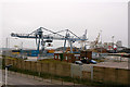
1
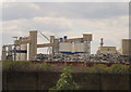
Industry in Tilbury Docks
Looking from the public road outside the docks, in the middle distances is a large heap of scrap metal on one wharf within the docks, and in the distance, various silos on another.
Image: © Stephen Craven
Taken: 10 Aug 2013
0.13 miles
3
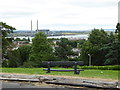
London Countryway in Kent (6)
Here's the view from Windmill Hill across Gravesend Reach to Tilbury in Essex. See also http://www.geograph.org.uk/photo/1947716.
Image: © Shazz
Taken: 10 Jul 2016
0.19 miles
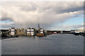
4
Tilbury Docks
A view of the docks from across the river at Northfleet.
Image: © Stephen Craven
Taken: 29 Oct 2005
0.20 miles
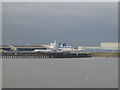
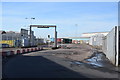
5
Tilbury Docks
This is the part of the docks to which the railway and St Andrew's Road (in the foreground) run parallel. Taken from the footbridge at Tilbury Town station.
Image: © David Kemp
Taken: 22 Mar 2019
0.24 miles
6
Tilbury Docks
Shot through the perimeter fence.
Image: © Trevor Harris
Taken: 16 Feb 2018
0.25 miles