IMAGES TAKEN NEAR TO
Adelaide Road, TILBURY, RM18 7BW
Introduction
This page details the photographs taken nearby to Adelaide Road, RM18 7BW by members of the Geograph project.
The Geograph project started in 2005 with the aim of publishing, organising and preserving representative images for every square kilometre of Great Britain, Ireland and the Isle of Man.

There are currently over 7.5m images from over14,400 individuals and you can help contribute to the project by visiting https://www.geograph.org.uk
Image Map
Images are licensed for reuse under creativecommons.org/licenses/by-sa/2.0
Notes
- Clicking on the map will re-center to the selected point.
- The higher the marker number, the further away the image location is from the centre of the postcode.
Image Listing (48 Images Found)
Images are licensed for reuse under creativecommons.org/licenses/by-sa/2.0
Image
Details
Distance
1
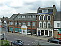
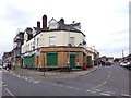
Premises on Dock Road, Tilbury
The lower large building is the Thurrock Irish Association Social Club, formerly a seamans' institute. The insurance building was formerly a bank.
Image: © Robin Webster
Taken: 10 Jul 2011
0.16 miles
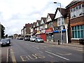
2
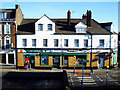
Tilbury High Street
Taken from the railway bridge.
Image: © Julieanne Savage
Taken: 25 Mar 2008
0.16 miles
3
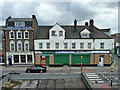
Premises on Dock Road, Tilbury
Including a former post office, housed, along with other businesses, in a former pub, The Ship.
Image: © Robin Webster
Taken: 10 Jul 2011
0.16 miles
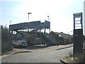
6
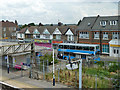
Rail replacement bus, Tilbury Town station
A Sunday, work was certainly going in here extending the platforms, probably elsewhere as well. The bus is bound for Upminster, doubtless calling at intermediate stations, which are Grays, Chafford Hundred and Ockendon.
Image: © Robin Webster
Taken: 10 Jul 2011
0.17 miles
8
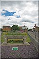
Tilbury Trough
This cattle trough is at a fork in the road wilh Calcutta Rd to the left and Dock Rd to the right. It was erected to mark the incorporation of Tilbury in 1912 see the dedication at Image for more info on the association see http://en.wikipedia.org/wiki/Metropolitan_Drinking_Fountain_and_Cattle_Trough_Association or http://www.drinkingfountains.org/main.html
Image: © Glyn Baker
Taken: 14 May 2011
0.17 miles
9
Tilbury Town Railway Station, Tilbury, Essex
Image: © John Winfield
Taken: 13 Jul 2005
0.17 miles
10
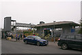
Tilbury Town station, down-side entrance
This is the station entrance that fronts Dock Road.
Image: © David Kemp
Taken: 22 Mar 2019
0.18 miles