IMAGES TAKEN NEAR TO
Whitehall Lane, GRAYS, RM17 6SS
Introduction
This page details the photographs taken nearby to Whitehall Lane, RM17 6SS by members of the Geograph project.
The Geograph project started in 2005 with the aim of publishing, organising and preserving representative images for every square kilometre of Great Britain, Ireland and the Isle of Man.

There are currently over 7.5m images from over14,400 individuals and you can help contribute to the project by visiting https://www.geograph.org.uk
Image Map
Images are licensed for reuse under creativecommons.org/licenses/by-sa/2.0
Notes
- Clicking on the map will re-center to the selected point.
- The higher the marker number, the further away the image location is from the centre of the postcode.
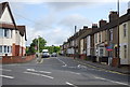
Image Listing (81 Images Found)
Images are licensed for reuse under creativecommons.org/licenses/by-sa/2.0
Image
Details
Distance
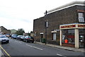
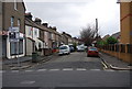
1
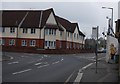
Junction of East Thurrock Rd & Whitehall Lane
Image: © N Chadwick
Taken: 8 Nov 2009
0.02 miles
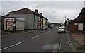
3
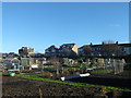
Whitehall Lane Allotment Gardens, Grays
A large plot of pland beside Whitehall Lane is used for allotments.
As seen from a footpath near Kent Road.
In the background are houses on Whitehall Lane. With one with castle-like features.
Image: © David Anstiss
Taken: 25 Nov 2012
0.04 miles
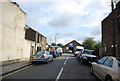
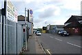
10
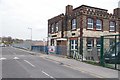
Barmy Battlements
Why on earth did the architect think you might need castilations on a brick building? The building is now a child care centre.
Image: © Glyn Baker
Taken: 1 Apr 2020
0.07 miles