IMAGES TAKEN NEAR TO
Harrap Chase, GRAYS, RM17 5EW
Introduction
This page details the photographs taken nearby to Harrap Chase, RM17 5EW by members of the Geograph project.
The Geograph project started in 2005 with the aim of publishing, organising and preserving representative images for every square kilometre of Great Britain, Ireland and the Isle of Man.

There are currently over 7.5m images from over14,400 individuals and you can help contribute to the project by visiting https://www.geograph.org.uk
Image Map (Loading...)


Getting Data...Please wait
Leaflet Map data © OpenStreetMap
Images are licensed for reuse under creativecommons.org/licenses/by-sa/2.0
Notes
- Clicking on the map will re-center to the selected point.
- The higher the marker number, the further away the image location is from the centre of the postcode.
Image Listing (10 Images Found)
Images are licensed for reuse under creativecommons.org/licenses/by-sa/2.0
Image
Details
Distance
1
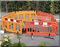
Hog Lane Sinkhole
On 29th May 2015 an HGV learner driver and his instructor had a nasty surprise when the back wheel of the truck caused a tunnel below Image to collapse. See http://www.bbc.co.uk/news/uk-england-essex-32930839 for the full story. Hog Lane is a "spine" of chalk between two disused chalk pits which ceased operations in the 1920's. The Western pit is now partly the Badgers Dene housing estate with its northern end being a nature reserve Image The eastern pit now houses the Titan Works industrial area. In former times narrow gauge railways passed under the road in several places, it is thought that one of these is the cause of the massive traffic disruption in Grays
Image: © Glyn Baker
Taken: 3 Jun 2015
0.13 miles
2
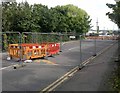
Hog Lane
Hog Lane is a "spine" of chalk between two disused chalk pits which ceased operations in the 1920's. It links the Image roundabout and central Grays. On 29th May 2015 an HGV learner driver and his instructor had a nasty surprise when the back wheel of the truck caused a tunnel below the road to collapse. See http://www.bbc.co.uk/news/uk-england-essex-32930839 for the full story. See also Image The Western pit is now partly the Badgers Dene housing estate with its northern end being a nature reserve Image The eastern pit now houses the Titan Works industrial area. In former times narrow gauge railways passed under the road in several places, it is thought that one of these is the cause of the massive traffic disruption in Grays
Image: © Glyn Baker
Taken: 3 Jun 2015
0.13 miles
4
Habitat Restoration in Grays Gorge
Grays Chalk Pit SSSI was being degraded in scientific interest as it was becoming secondary woodland. Tree felling is the first stage of restoring 50% of the floor of the pit to chalk grassland supporting rare plants and invertebrates which was why the SSSI designation was earned.
The site is owned and managed by Essex Wildlife Trust http://www.essexwt.org.uk/.
Image: © Glyn Baker
Taken: 17 Oct 2014
0.20 miles
5
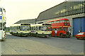
Grays bus garage, 1989
The garage is now demolished and the area a car park. The red RT bus was not allocated here, but just paying a visit on the way back to Canvey Island from a rally in London. There was a time in the past, in London Transport days, when all of the Grays buses were RTs, but green.
Image: © Robin Webster
Taken: 6 Aug 1989
0.22 miles
6
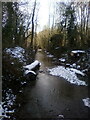
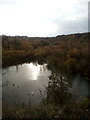
Grays Gorge
A frozen ditch in a south eastern corner of Grays Gorge, a former chalk quarry and now part of the Chafford Gorges Nature Park.
Image: © Adrian Benn
Taken: 13 Feb 2021
0.22 miles
7
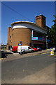
Mecca Bingo hall, Grays
Formerly the Ritz cinema, it was built in the Moderne style to the designs of architect E.Hamilton Parke in 1939, and opened in 1940. Closed in 1976. One of two Grade II (http://list.english-heritage.org.uk/resultsingle.aspx?uid=1384993) or above listed former cinemas in Grays. Bingo operations have served to save redundant cinema buildings, in the same way that public house chains have given new life to post office buildings.
Image: © Jim Osley
Taken: 9 Jul 2013
0.22 miles
8
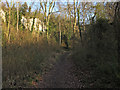
A Path Through Grays Gorge
Some of the secondary woodland that was not part of the Image
Image: © Glyn Baker
Taken: 27 Feb 2018
0.24 miles
9

A Grays Grey
Image: © Glyn Baker
Taken: 27 Feb 2018
0.24 miles
10
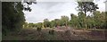
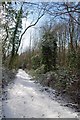
Path through Grays Gorge
Grays Gorge is an SSSI and part of Chafford Gorges Nature Park.
Note the chalk cliffs in the background.
Image: © Roger Jones
Taken: 6 Apr 2013
0.24 miles