IMAGES TAKEN NEAR TO
Woolings Close, GRAYS, RM16 3AT
Introduction
This page details the photographs taken nearby to Woolings Close, RM16 3AT by members of the Geograph project.
The Geograph project started in 2005 with the aim of publishing, organising and preserving representative images for every square kilometre of Great Britain, Ireland and the Isle of Man.

There are currently over 7.5m images from over14,400 individuals and you can help contribute to the project by visiting https://www.geograph.org.uk
Image Map (Loading...)


Getting Data...Please wait
Leaflet Map data © OpenStreetMap
Images are licensed for reuse under creativecommons.org/licenses/by-sa/2.0
Notes
- Clicking on the map will re-center to the selected point.
- The higher the marker number, the further away the image location is from the centre of the postcode.
Image Listing (6 Images Found)
Images are licensed for reuse under creativecommons.org/licenses/by-sa/2.0
Image
Details
Distance
2
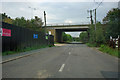
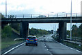
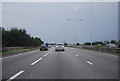
Baker Street passes under the A13
Further on, it also passes under the spur road from the westbound A13 to the A1089 to Tilbury. On the left, the hoardings appear to be around the forthcoming 'Orsett Grange' housing development, which is on an old industrial site.
Image: © Robin Webster
Taken: 18 Sep 2011
0.08 miles