IMAGES TAKEN NEAR TO
Sandown Close, GRAYS, RM16 3AQ
Introduction
This page details the photographs taken nearby to Sandown Close, RM16 3AQ by members of the Geograph project.
The Geograph project started in 2005 with the aim of publishing, organising and preserving representative images for every square kilometre of Great Britain, Ireland and the Isle of Man.

There are currently over 7.5m images from over14,400 individuals and you can help contribute to the project by visiting https://www.geograph.org.uk
Image Map
Images are licensed for reuse under creativecommons.org/licenses/by-sa/2.0
Notes
- Clicking on the map will re-center to the selected point.
- The higher the marker number, the further away the image location is from the centre of the postcode.
Image Listing (6 Images Found)
Images are licensed for reuse under creativecommons.org/licenses/by-sa/2.0
Image
Details
Distance
1
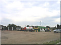
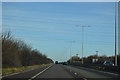
Transport Cafe, the old A13, Orsett
A well known transport cafe (Les' Cafe) on A1013 - which used to be the main London-Southend road
Image: © John Winfield
Taken: 23 Sep 2005
0.10 miles
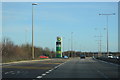
5
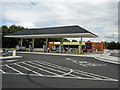
New petrol station
This petrol station on the A13 was only recently rebuilt.
Image: © Roger Jones
Taken: 19 Jun 2011
0.19 miles