IMAGES TAKEN NEAR TO
Green Lane, GRAYS, RM16 3AN
Introduction
This page details the photographs taken nearby to Green Lane, RM16 3AN by members of the Geograph project.
The Geograph project started in 2005 with the aim of publishing, organising and preserving representative images for every square kilometre of Great Britain, Ireland and the Isle of Man.

There are currently over 7.5m images from over14,400 individuals and you can help contribute to the project by visiting https://www.geograph.org.uk
Image Map
Images are licensed for reuse under creativecommons.org/licenses/by-sa/2.0
Notes
- Clicking on the map will re-center to the selected point.
- The higher the marker number, the further away the image location is from the centre of the postcode.
Image Listing (7 Images Found)
Images are licensed for reuse under creativecommons.org/licenses/by-sa/2.0
Image
Details
Distance
1

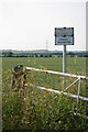
Orsett Fen Track
A farm track that sadly does not form part of the "right to roam" area to the north of here.
Image: © Glyn Baker
Taken: 26 Jun 2010
0.13 miles
2
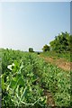
Across Orsett Fen
A wheat field in Orsett Fen
Image: © Glyn Baker
Taken: 26 Jun 2010
0.13 miles
3
Footpath to Bulphan Fen
This footpath passes through the Orsett Fen "Right to roam" area and on to Bulphan Fen.
Image: © Glyn Baker
Taken: 26 Jun 2010
0.13 miles
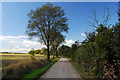
4
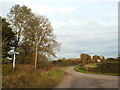
Fen Lane, near Orsett
Fen Lane, photographed at the junction with Green Lane.
Image: © Malc McDonald
Taken: 28 Oct 2017
0.14 miles
5
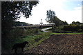
(Covid-19_29 Exercise) Green Lane Fen Lane Junction
Footpath 90 to Bulphan Fen is to the left.
For the start of this journey go to Image
For the next square visit Image
Image: © Glyn Baker
Taken: 24 Mar 2020
0.14 miles
6
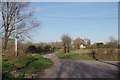
"Crossroads" near Poplars Farm
Ahead is the junction of the footpath I am approaching on, Green Lane to the right and fen lane ahead and to the left.
Image: © Trevor Harris
Taken: 19 Sep 2011
0.14 miles
7
Green Lane, Orsett
A bridleway towards Stifford Clays.
Image: © Trevor Harris
Taken: 19 Sep 2011
0.15 miles