IMAGES TAKEN NEAR TO
Buxton Road, GRAYS, RM16 2WU
Introduction
This page details the photographs taken nearby to Buxton Road, RM16 2WU by members of the Geograph project.
The Geograph project started in 2005 with the aim of publishing, organising and preserving representative images for every square kilometre of Great Britain, Ireland and the Isle of Man.

There are currently over 7.5m images from over14,400 individuals and you can help contribute to the project by visiting https://www.geograph.org.uk
Image Map
Images are licensed for reuse under creativecommons.org/licenses/by-sa/2.0
Notes
- Clicking on the map will re-center to the selected point.
- The higher the marker number, the further away the image location is from the centre of the postcode.
Image Listing (7 Images Found)
Images are licensed for reuse under creativecommons.org/licenses/by-sa/2.0
Image
Details
Distance
1
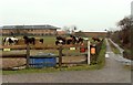
Horses at Orsett Heath
The track on the right is private and leads down to the school that is standing in the background.
Image: © Robert Edwards
Taken: 10 Mar 2008
0.13 miles
2
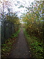
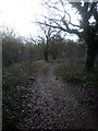
Path alongside playing fields
The footpath to Orsett Heath squeezed between playing fields and the A1089
Image: © Adrian Benn
Taken: 9 Nov 2020
0.17 miles
4
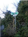
Bridleway Sign in Orsett Heath
The path leads under the A1089 which links Tilbury with the A13.
Image: © Adrian Benn
Taken: 3 Jan 2021
0.22 miles
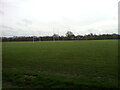
6
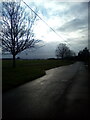
Farm Road, Orsett Heath
Looking towards the recreation ground
Image: © Adrian Benn
Taken: 3 Jan 2021
0.24 miles
7
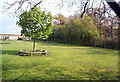
Woodside School and Terrel's Heath
Between Woodside school (on the left) and Terrel's Heath is an ancient bank and ditch that formed the parish boundary between Little Thurrock and Chadwell.
Image: © John Matthews
Taken: 18 Apr 1999
0.24 miles