IMAGES TAKEN NEAR TO
Wood View, GRAYS, RM16 2WJ
Introduction
This page details the photographs taken nearby to Wood View, RM16 2WJ by members of the Geograph project.
The Geograph project started in 2005 with the aim of publishing, organising and preserving representative images for every square kilometre of Great Britain, Ireland and the Isle of Man.

There are currently over 7.5m images from over14,400 individuals and you can help contribute to the project by visiting https://www.geograph.org.uk
Image Map
Images are licensed for reuse under creativecommons.org/licenses/by-sa/2.0
Notes
- Clicking on the map will re-center to the selected point.
- The higher the marker number, the further away the image location is from the centre of the postcode.
Image Listing (49 Images Found)
Images are licensed for reuse under creativecommons.org/licenses/by-sa/2.0
Image
Details
Distance
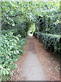
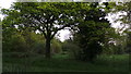
1
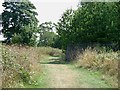
The southern edge of Hangman's Wood
The main path traversing Hangman's Wood.
Image: © Adrian Benn
Taken: 9 Nov 2020
0.07 miles
2
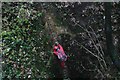
Dene hole - Hangman's wood SSSI.
The long climb out of a Dene hole after 4 hours underground monitoring bats.
Image: © Simon Leatherdale
Taken: 8 Jan 2006
0.08 miles
4
Terrells Heath / Hangmans Wood Grays
The galvanized fence protects the public from falling into a Denehole. There is great debate as to what a Denehole is. It has not been conclusively proved if they are natural or man made. The name derives from Dane Hole a place where people hid during Viking raids although there is little proof they were used for this reason.
Image: © Glyn Baker
Taken: 18 Aug 2005
0.10 miles
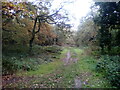
8
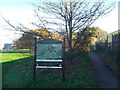
Path beside Hangman's Wood, Little Thurrock
This path is part of a bridleway leading from Little Thurrock towards Chadwell St Mary.
In the wood on the left, are deneholes. Which are underground structures consisting of a number of small chalk caves entered by a vertical shaft. Constructed by the Danes.
The sign gives a history of the site.
Image: © David Anstiss
Taken: 25 Nov 2012
0.11 miles