IMAGES TAKEN NEAR TO
Long Lane, GRAYS, RM16 2QH
Introduction
This page details the photographs taken nearby to Long Lane, RM16 2QH by members of the Geograph project.
The Geograph project started in 2005 with the aim of publishing, organising and preserving representative images for every square kilometre of Great Britain, Ireland and the Isle of Man.

There are currently over 7.5m images from over14,400 individuals and you can help contribute to the project by visiting https://www.geograph.org.uk
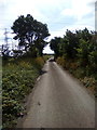
Image Map
Images are licensed for reuse under creativecommons.org/licenses/by-sa/2.0
Notes
- Clicking on the map will re-center to the selected point.
- The higher the marker number, the further away the image location is from the centre of the postcode.
Image Listing (18 Images Found)
Images are licensed for reuse under creativecommons.org/licenses/by-sa/2.0
Image
Details
Distance
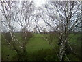
1
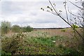
Undeveloped Land and Harrowed field
With the pressure to build new houses the bit of green to the left of the fence would seem a prime site for some affordable houses.
Image: © Glyn Baker
Taken: 31 Mar 2020
0.06 miles
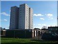
2
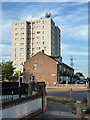
Long Lane, Keir Hardy House & Thurrock RFC Sign
No prizes for guessing the colour of the local Council when this block was named! The road past the trees is the drive to Thurrock Rugby Football Club.
Image: © Glyn Baker
Taken: 31 Mar 2020
0.10 miles
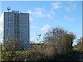
3
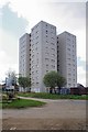
Keir Hardie House
It towers above houses in Milford Road.
Image: © Robin Webster
Taken: 4 Jul 2015
0.10 miles
4
Kier Hardie House, Little Thurrock
As seen from Long Lane, across a block of garages.
Image: © David Anstiss
Taken: 25 Nov 2012
0.11 miles
5
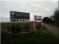
Thurrock Rugby Football Club
Signs at the head of the lane leading to Thurrock Rugby Football Club which is adjacent to the newly opened Orsett Heath Academy
Image: © Adrian Benn
Taken: 11 Nov 2020
0.13 miles
6
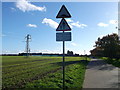
Lane to Thurrock Rugby Football Club
This narrow lane leads from Long Lane to the changing rooms, club house of the sports club.
Image: © David Anstiss
Taken: 25 Nov 2012
0.13 miles
7
Long Lane towards Little Thurrock
Leads from Gammon Field Caravan site/estate to the town.
On the left is Keir Hardie House, block of flats.
Image: © David Anstiss
Taken: 25 Nov 2012
0.13 miles
8
Bevan House and Morrison House, Grays
Peeping between them but a good deal further away is the similar Keir Hardie House. A view from Blackshots playing fields.
Image: © Robin Webster
Taken: 4 Jul 2015
0.19 miles
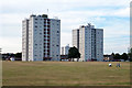
9
View Across King George Field
Bevan House and Morrison House can be seen in the background.
Image: © Adrian Benn
Taken: 29 Dec 2020
0.20 miles