IMAGES TAKEN NEAR TO
Ashley Gardens, GRAYS, RM16 2LR
Introduction
This page details the photographs taken nearby to Ashley Gardens, RM16 2LR by members of the Geograph project.
The Geograph project started in 2005 with the aim of publishing, organising and preserving representative images for every square kilometre of Great Britain, Ireland and the Isle of Man.

There are currently over 7.5m images from over14,400 individuals and you can help contribute to the project by visiting https://www.geograph.org.uk
Image Map (Loading...)


Getting Data...Please wait
Leaflet Map data © OpenStreetMap
Images are licensed for reuse under creativecommons.org/licenses/by-sa/2.0
Notes
- Clicking on the map will re-center to the selected point.
- The higher the marker number, the further away the image location is from the centre of the postcode.
Image Listing (9 Images Found)
Images are licensed for reuse under creativecommons.org/licenses/by-sa/2.0
Image
Details
Distance
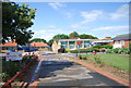
2
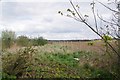
Undeveloped Land and Harrowed field
With the pressure to build new houses the bit of green to the left of the fence would seem a prime site for some affordable houses.
Image: © Glyn Baker
Taken: 31 Mar 2020
0.17 miles
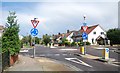
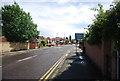
4
Mini Roundabout on Long Lane, Little Thurrock
Long Lane leads straight on towards the A1012 Lodge Lane.
Blackshots Lane leads right towards Bloomfields Farm, it also leads left towards Little Thurrock.
Image: © David Anstiss
Taken: 25 Nov 2012
0.21 miles
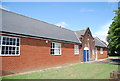
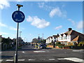
6
Kent House, Thurrock Community Hospital
On Long Lane
Image: © David Anstiss
Taken: 25 Nov 2012
0.23 miles
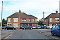
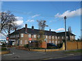
9
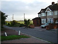
Last House on Blackshots Lane
During the 1930’s Grays extended northwards towards Orsett particularly ribbon development along Blackshots and Long Lane. Post war there was much infill but the town and country planning act has ensured there is some countryside between them. This is the point where town and country meet.
Image: © Glyn Baker
Taken: 25 Aug 2005
0.25 miles