IMAGES TAKEN NEAR TO
Woodside Close, GRAYS, RM16 2ES
Introduction
This page details the photographs taken nearby to Woodside Close, RM16 2ES by members of the Geograph project.
The Geograph project started in 2005 with the aim of publishing, organising and preserving representative images for every square kilometre of Great Britain, Ireland and the Isle of Man.

There are currently over 7.5m images from over14,400 individuals and you can help contribute to the project by visiting https://www.geograph.org.uk
Image Map
Images are licensed for reuse under creativecommons.org/licenses/by-sa/2.0
Notes
- Clicking on the map will re-center to the selected point.
- The higher the marker number, the further away the image location is from the centre of the postcode.
Image Listing (19 Images Found)
Images are licensed for reuse under creativecommons.org/licenses/by-sa/2.0
Image
Details
Distance
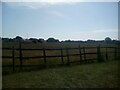
1
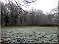
Site of Thurrock Technical College
The site of playing fields attached to Thurrock Technical College (1955-2015). The new housing is on the site of the college itself. The woodland in the distance is known as Terrel's Heath.
Image: © Adrian Benn
Taken: 9 Nov 2020
0.07 miles
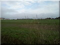
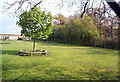
2
Grassland on former playing fields
Grassland, formerly playing fields attached to the former Thurrock Technical College. This forms part of an important mini greenbelt between Grays and Chadwell-St-Mary
Image: © Adrian Benn
Taken: 9 Nov 2020
0.07 miles
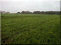
3
Former playing field
The former playing field for Thurrock Technical College seen through a broken section of the original perimeter fence.
Image: © Adrian Benn
Taken: 9 Nov 2020
0.11 miles
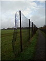
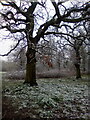
4
Woodside School and Terrel's Heath
Between Woodside school (on the left) and Terrel's Heath is an ancient bank and ditch that formed the parish boundary between Little Thurrock and Chadwell.
Image: © John Matthews
Taken: 18 Apr 1999
0.12 miles
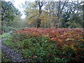
6
Winter Trees in Terrels Heath
A dusting of snow in this small area of woodland between Grays and Orsett Heath.
Image: © Adrian Benn
Taken: 7 Feb 2021
0.12 miles
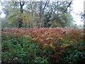
9
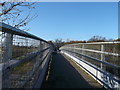
Bridleway bridge over Dock Approach Road
A bridleway leads from Heath Road, Chadwell St. Mary to Little Thurrock.
It passes over the (A1089) dual carriageway between Tilbury and the A13.
In the background is Terrels Heath (woodland and scrub area).
Image: © David Anstiss
Taken: 25 Nov 2012
0.18 miles