IMAGES TAKEN NEAR TO
Hall Lane, SOUTH OCKENDON, RM15 6SL
Introduction
This page details the photographs taken nearby to Hall Lane, RM15 6SL by members of the Geograph project.
The Geograph project started in 2005 with the aim of publishing, organising and preserving representative images for every square kilometre of Great Britain, Ireland and the Isle of Man.

There are currently over 7.5m images from over14,400 individuals and you can help contribute to the project by visiting https://www.geograph.org.uk
Image Map
Images are licensed for reuse under creativecommons.org/licenses/by-sa/2.0
Notes
- Clicking on the map will re-center to the selected point.
- The higher the marker number, the further away the image location is from the centre of the postcode.
Image Listing (13 Images Found)
Images are licensed for reuse under creativecommons.org/licenses/by-sa/2.0
Image
Details
Distance
1
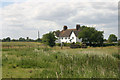
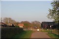
Hope Cottages, Hall Lane, South Ockendon
Image: © David Kemp
Taken: 15 Jun 2015
0.02 miles
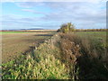
2
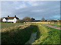
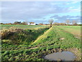
Drain, Hall Lane and Hope Cottages
A lane leads from Fen Farm, past South Ockendon Hall farm towards North Road, South Ockendon.
On the left is a field drain around a large field.
Hope Cottages, part of the farm are seen in the background.
Image: © David Anstiss
Taken: 25 Nov 2012
0.04 miles
3
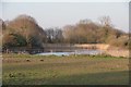
Moat Near The Mount
There is a "listed" brick bridge over this moat see https://historicengland.org.uk/listing/the-list/list-entry/1147701
Image: © Glyn Baker
Taken: 27 Mar 2020
0.05 miles
4

Ruins At Ockendon Hall
The ruins seen through the trees and across the moat are probably that of the undershot wheel water mill that stood on this site. Unusually the milling business had dual power there was also the substantial remains of a wooden windmill on the site until it collapsed during a gale in November 1977. NB there is a mistake on older OS maps that refer to Ockenden Hall rather than Ockendon, a common mistake.
Image: © Glyn Baker
Taken: 21 Aug 2005
0.07 miles
5
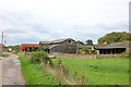
Barns and outbuildings at South Ockendon Hall
Image: © Trevor Harris
Taken: 12 Oct 2013
0.08 miles
6
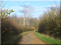
Evening Light on Ockendon Hall Farm
Looking along footpath 136 to Fen Lane
Image: © Glyn Baker
Taken: 27 Mar 2020
0.09 miles
7
Drain and path towards South Ockendon Hall
A path leads from Great Mollands Farm, Mollands Lane straight on towards Hall Lane.
Another path leads left along the field drain towards The Green, South Ockendon.
Hope Cottages are seen in the background.
Image: © David Anstiss
Taken: 25 Nov 2012
0.14 miles
8
Hall Lane to Fen Farm
This lane leads from South Ockendon past South Ockendon Hall Farm towards the farm on Fen Lane.
Image: © David Anstiss
Taken: 25 Nov 2012
0.15 miles
9
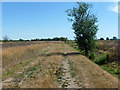
Thurrock footpath 132, South Ockendon
This northern part is a beautifully clear path as far as the junction with footpath 134 off to the right ahead, which is similarly clear. However straight on towards Grange Farm is very much a different matter - see Image
Image: © Robin Webster
Taken: 4 Jul 2015
0.15 miles
10
Field Ditch, near South Ockendon Hall
As seen from a footpath between Great Mollands Farm and South Ockendon Hall.
This field drain leads eastwards.
Image: © David Anstiss
Taken: 25 Nov 2012
0.16 miles