IMAGES TAKEN NEAR TO
Cherwell Grove, SOUTH OCKENDON, RM15 6AS
Introduction
This page details the photographs taken nearby to Cherwell Grove, RM15 6AS by members of the Geograph project.
The Geograph project started in 2005 with the aim of publishing, organising and preserving representative images for every square kilometre of Great Britain, Ireland and the Isle of Man.

There are currently over 7.5m images from over14,400 individuals and you can help contribute to the project by visiting https://www.geograph.org.uk
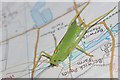
Image Map
Images are licensed for reuse under creativecommons.org/licenses/by-sa/2.0
Notes
- Clicking on the map will re-center to the selected point.
- The higher the marker number, the further away the image location is from the centre of the postcode.
Image Listing (20 Images Found)
Images are licensed for reuse under creativecommons.org/licenses/by-sa/2.0
Image
Details
Distance
1
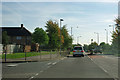
Stifford Road at Cander Way junction
There is a large post-war housing estate to the left, and some further housing to the right.
Image: © Robin Webster
Taken: 15 Sep 2011
0.04 miles
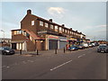
2
Cherwell Grove, South Ockendon
Cherwell Grove in South Ockendon.
Image: © Malc McDonald
Taken: 28 Oct 2017
0.05 miles
3
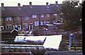
Gardens in Cherwell Grove
Looking from Corran Way into the back Gardens of Cherwell Grove
Image: © Glyn Baker
Taken: Unknown
0.06 miles
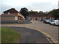
4
Shops on Broxburn Drive, South Ockendon
A parade of shops with flats above, on Broxburn Drive in South Ockendon.
Image: © Malc McDonald
Taken: 28 Oct 2017
0.10 miles
5
Geographers Little Helper
This little fella came along to help while uploading some photos. I think he is a Long-winged cone head cricket Conocephalus discolor
Image: © Glyn Baker
Taken: 7 Aug 2009
0.13 miles
6
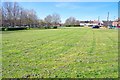
(Covid-19_1 Exercise) Callan Grove Green
Mr Johnson said I could leave the house once a day for a bike ride; I took him at his word! For the rest of the exercise most of the time I was never less than 100m from the next person or passing them at a good distance doing about 8kph.
Sadly Thurrock Council want to build on this green space see https://consult.thurrock.gov.uk/SaveCallanGrovePetition?tool=survey_tool&tool_id=sign-petition&ts=1585077595#tool_tab it is a bit of a green desert but the 1950's planners put it there for sound reasons and those reasons haven't changed at all in 60+ years.
For the next square on the journey see Image
Image: © Glyn Baker
Taken: 24 Mar 2020
0.13 miles
7
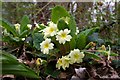
Primula vulgaris
These Primroses are in Brannets Wood part of Thames Chase http://www.thameschase.org.uk/what.html
Image: © Glyn Baker
Taken: 10 Apr 2007
0.16 miles
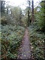
9
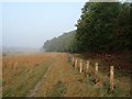
Morning Mist in Mardyke Valley
Technically the path behind the fence on the right is a permissive link for horse traffic. It follows the water meadows of the Mardyke River valley through the country park from Stifford Bridge to Ship Lane Aveley, it is not marked as a public right of way on OS Maps. Clearly walkers vote with their feet and stay to the left of the fence. The photograph was taken at the edge of Brannets Wood (the second oldest woodland in Essex) http://www.forestry.gov.uk/website/recreation.nsf/LUWebDocsByKey/EnglandEssexNoForestThamesChaseCommunityForestMardykeWoods looking towards the A13/M25 interchange.
Image: © Glyn Baker
Taken: 18 Aug 2005
0.18 miles
10
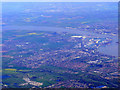
Grays and Tilbury Docks from the air
South Ockendon is at the bottom of the photo, with Thurrock across the A13 dual carriageway. Gravesend is visible across the Thames. Viewed from a Prague bound flight from Heathrow.
Image: © Thomas Nugent
Taken: 10 Apr 2011
0.19 miles