IMAGES TAKEN NEAR TO
Daiglen Drive, SOUTH OCKENDON, RM15 5RW
Introduction
This page details the photographs taken nearby to Daiglen Drive, RM15 5RW by members of the Geograph project.
The Geograph project started in 2005 with the aim of publishing, organising and preserving representative images for every square kilometre of Great Britain, Ireland and the Isle of Man.

There are currently over 7.5m images from over14,400 individuals and you can help contribute to the project by visiting https://www.geograph.org.uk
Image Map
Images are licensed for reuse under creativecommons.org/licenses/by-sa/2.0
Notes
- Clicking on the map will re-center to the selected point.
- The higher the marker number, the further away the image location is from the centre of the postcode.
Image Listing (11 Images Found)
Images are licensed for reuse under creativecommons.org/licenses/by-sa/2.0
Image
Details
Distance
1
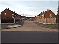
Cample Lane, South Ockendon
Cample Lane in South Ockendon.
Image: © Malc McDonald
Taken: 28 Oct 2017
0.06 miles
2
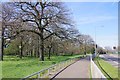
(Covid-19_2 Exercise) Millards Garden and B1335
Millard's Garden is a public open space and play area on the edge of Branetts Wood. For the start of this exercise trip see Image
to go to the next square see Image
Image: © Glyn Baker
Taken: 24 Mar 2020
0.14 miles
3
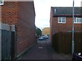
Alleyway, South Ockendon
This alley path leads between Dale Close and Dent Close.
Image: © David Anstiss
Taken: 25 Nov 2012
0.19 miles
4
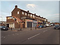
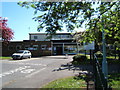
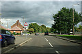
Shops on Broxburn Drive, South Ockendon
A parade of shops with flats above, on Broxburn Drive in South Ockendon.
Image: © Malc McDonald
Taken: 28 Oct 2017
0.21 miles
5
Cluver Centre Polling Station
Election Officials at Belhus Ward do not appear to be rushed off their feat today. The South Ockendon Youth Centre plays host to a polling station. No queues not even party workers checking poll cards, no solitary special constable standing on guard. This election I only spotted one political poster in the whole ward on the side of a double glazing van. Canvassers were notable by their absence, no loud hailer vans, only the leafleters seemed active. A marked contrast to 1997 when almost every other window seemed to sport electoral opinions of one colour or another. With the loss of the personal vote for the excellent retiring M.P the seat of Thurrock changed colour on the back of 97 votes.
Image: © Glyn Baker
Taken: 6 May 2010
0.22 miles
6
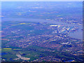
Grays and Tilbury Docks from the air
South Ockendon is at the bottom of the photo, with Thurrock across the A13 dual carriageway. Gravesend is visible across the Thames. Viewed from a Prague bound flight from Heathrow.
Image: © Thomas Nugent
Taken: 10 Apr 2011
0.23 miles
7

Dilkes Park Ockendon
Looking from the Fairham Ave side of the park
Image: © Glyn Baker
Taken: 30 Mar 2008
0.23 miles
8
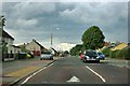
Foyle Drive, South Ockendon
Nice long straight + residential area + many junctions = speed bumps!
Image: © Robin Webster
Taken: 18 Sep 2011
0.23 miles
9
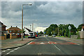
Foyle Drive, South Ockendon
Nice long straight + residential area + many junctions = speed bumps!
Image: © Robin Webster
Taken: 18 Sep 2011
0.24 miles
10
Stifford Road (old route) near corner into Foyle Drive
The B1335 over to the right has bypassed this bit of Stifford Road, which now just acts as a lead in to Foyle Drive, left at the bend.
Image: © Robin Webster
Taken: 18 Sep 2011
0.24 miles