IMAGES TAKEN NEAR TO
Stifford Road, SOUTH OCKENDON, RM15 5NF
Introduction
This page details the photographs taken nearby to Stifford Road, RM15 5NF by members of the Geograph project.
The Geograph project started in 2005 with the aim of publishing, organising and preserving representative images for every square kilometre of Great Britain, Ireland and the Isle of Man.

There are currently over 7.5m images from over14,400 individuals and you can help contribute to the project by visiting https://www.geograph.org.uk
Image Map
Images are licensed for reuse under creativecommons.org/licenses/by-sa/2.0
Notes
- Clicking on the map will re-center to the selected point.
- The higher the marker number, the further away the image location is from the centre of the postcode.
Image Listing (11 Images Found)
Images are licensed for reuse under creativecommons.org/licenses/by-sa/2.0
Image
Details
Distance
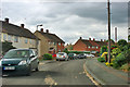
1
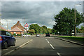
Stifford Road (old route) near corner into Foyle Drive
The B1335 over to the right has bypassed this bit of Stifford Road, which now just acts as a lead in to Foyle Drive, left at the bend.
Image: © Robin Webster
Taken: 18 Sep 2011
0.03 miles
2
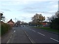
Stifford Road, South Ockendon
There are 2 Stifford Roads, here.
One minor road that leads towards Foyle Drive (around the bend on the left).
Or the B1335 (on the right) that leads to the B186 South Road.
Image: © David Anstiss
Taken: 25 Nov 2012
0.06 miles
3
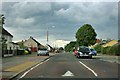
Foyle Drive, South Ockendon
Nice long straight + residential area + many junctions = speed bumps!
Image: © Robin Webster
Taken: 18 Sep 2011
0.12 miles
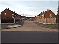
4
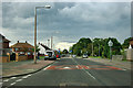
Foyle Drive, South Ockendon
Nice long straight + residential area + many junctions = speed bumps!
Image: © Robin Webster
Taken: 18 Sep 2011
0.14 miles
5
Fullarton Crescent, South Ockendon
Very nearly a semicircle, from and to Foyle Drive.
Image: © Robin Webster
Taken: 18 Sep 2011
0.15 miles
6

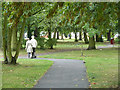
Dilkes Park Ockendon
Looking from the Fairham Ave side of the park
Image: © Glyn Baker
Taken: 30 Mar 2008
0.21 miles
7
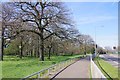
(Covid-19_2 Exercise) Millards Garden and B1335
Millard's Garden is a public open space and play area on the edge of Branetts Wood. For the start of this exercise trip see Image
to go to the next square see Image
Image: © Glyn Baker
Taken: 24 Mar 2020
0.21 miles
8
Cample Lane, South Ockendon
Cample Lane in South Ockendon.
Image: © Malc McDonald
Taken: 28 Oct 2017
0.22 miles
9
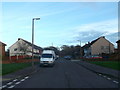
Gatehope Drive, South Ockendon
This road leads to Foyle Drive from Fullarton Crescent.
In the background is Dilkes Park.
Image: © David Anstiss
Taken: 25 Nov 2012
0.22 miles
10
Dilkes Park
A small park with a basketball/netball court and children's play apparatus, but otherwise quietly park-like.
Image: © Robin Webster
Taken: 18 Sep 2011
0.23 miles