IMAGES TAKEN NEAR TO
Romford Road, SOUTH OCKENDON, RM15 4XH
Introduction
This page details the photographs taken nearby to Romford Road, RM15 4XH by members of the Geograph project.
The Geograph project started in 2005 with the aim of publishing, organising and preserving representative images for every square kilometre of Great Britain, Ireland and the Isle of Man.

There are currently over 7.5m images from over14,400 individuals and you can help contribute to the project by visiting https://www.geograph.org.uk
Image Map
Images are licensed for reuse under creativecommons.org/licenses/by-sa/2.0
Notes
- Clicking on the map will re-center to the selected point.
- The higher the marker number, the further away the image location is from the centre of the postcode.
Image Listing (11 Images Found)
Images are licensed for reuse under creativecommons.org/licenses/by-sa/2.0
Image
Details
Distance
1
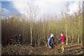
Coppicing
Woodland Trust http://www.woodlandtrust.org.uk/en/Pages/default.aspx#.UPB9LW9SjNs Volunteers take the Image of hazel at Image
Image: © Glyn Baker
Taken: 9 Dec 2012
0.04 miles
2
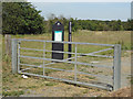
Entrance to Belhus Chase
This entrance to Belhus Chase (Woodland Trust) is often used by dog walkers and locals who prefer not to pay for the car park at the nearby country park. It is on the Romford Road near Aveley.
Image: © Roger Jones
Taken: 1 Jun 2011
0.05 miles
3
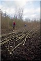
First Cut
A rite of passage for Image as Woodland Trust volunteers cut the first crop of a hazel plantation. Image is a traditional method of woodland management see http://en.wikipedia.org/wiki/Coppicing. Other broad leaf species (such as Ash) in the planting area are being left as standards. So far no sign of Ash die back fingers and toes are all crossed!
Image: © Glyn Baker
Taken: 9 Dec 2012
0.06 miles
4
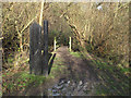
Entrance to Running Water Wood
A bridge over Running Water Brook leads into Running Water Wood at Belhus Woods Country Park.
Image: © Roger Jones
Taken: 22 Dec 2013
0.15 miles
5
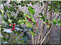
Holly and berries
Holly with berries in Running Water Wood.
Image: © Roger Jones
Taken: 22 Dec 2013
0.17 miles
6
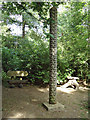
Totem Pole, Belhus
This pole was created from a local oak that fell in the 1987 gales.
Image: © Roger Jones
Taken: 1 Jun 2011
0.17 miles
7
Henry's Moat
Not every pub has a medieval moat protecting its car park. This one would discourage anyone from crossing it who didn’t want to get decidedly smelly! The medieval manor house was converted into a pub in the early 1980’s as the Sir Henry Gurnett (a former resident) it has been through several hands since then and is now “Henry’s”.
Image: © Glyn Baker
Taken: 21 Aug 2005
0.19 miles
8
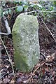
Old Milestone in Belhus Woods Country Park, Aveley parish
Carved stone post by the UC road, in parish of AVELEY (HAVERING District), by old footpath parallel to road within Belhus Woods Country Park, by the road, on East side of road. Erected by an unknown authority in the 19th century.
Inscription once read:-
(London 18)
(Romford 6)
Milestone Society National ID: EX_RDAV18.
Image: © JV Nicholls
Taken: 26 Feb 2011
0.21 miles
9
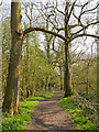
Spring sunshine in Running Water Wood, Belhus Woods Country Park
Image: © Roger Jones
Taken: 14 Apr 2018
0.22 miles
10
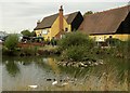
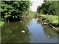
Henry's Restaurant
For centuries, the building known as the Sir Henry Gurnett was known as Kenningtons. It was built between 1275 and 1310 as a timber-framed, two storey dwelling, with an aisled hall. Later this aisle was removed and a south hall was added. Chimneys were built in the 17th century with further alterations made in the 19th century and other changes were necessary when Kenningtons became a public house. The remains of the original moat, as seen in the picture, is now a pleasant pond for ducks.
Image: © Robert Edwards
Taken: 2 Oct 2009
0.23 miles