
IMAGES TAKEN NEAR TO
Nethan Drive, SOUTH OCKENDON, RM15 4RT
Introduction
This page details the photographs taken nearby to Nethan Drive, RM15 4RT by members of the Geograph project.
The Geograph project started in 2005 with the aim of publishing, organising and preserving representative images for every square kilometre of Great Britain, Ireland and the Isle of Man.

There are currently over 7.5m images from over14,400 individuals and you can help contribute to the project by visiting https://www.geograph.org.uk
Image Map
Images are licensed for reuse under creativecommons.org/licenses/by-sa/2.0
Notes
- Clicking on the map will re-center to the selected point.
- The higher the marker number, the further away the image location is from the centre of the postcode.
Image Listing (7 Images Found)
Images are licensed for reuse under creativecommons.org/licenses/by-sa/2.0
Image
Details
Distance
1
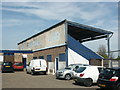
Back of the Main Stand, Aveley FC
Home of The Millers since 1952
Image: © Stuart Shepherd
Taken: 25 Apr 2008
0.10 miles
2
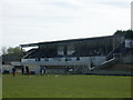
The Main Stand, Aveley FC
An impressive, if not a little careworn, edifice for a team playing a long way down the football pyramid.
Image: © Stuart Shepherd
Taken: 26 Apr 2008
0.11 miles
3
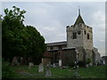
Timeless (St Michael's Aveley)
The clock has said nearly twenty to four for as long as I can recall!
(update:- since the photo was taken the clock appears to have been mended)
Image: © Glyn Baker
Taken: 9 Aug 2005
0.14 miles
4
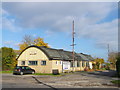
St Michael's Church Hall
On Mill Road, beside an access road to Mill Field recreational ground.
Image: © David Anstiss
Taken: 7 Nov 2012
0.21 miles
5
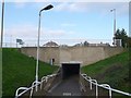
Aveley Underpass
This foot tunnel leads from Mill Road towards Nethen Drive.
It passes under the Aveley By-pass (the B1335).
Image: © David Anstiss
Taken: 7 Nov 2012
0.23 miles

7

Roundabout on Mill Road, Aveley
Joining Sandy Lane.
Image: © David Howard
Taken: 8 Oct 2025
0.25 miles