IMAGES TAKEN NEAR TO
Upper Bedfords View, ROMFORD, RM1 4FA
Introduction
This page details the photographs taken nearby to Upper Bedfords View, RM1 4FA by members of the Geograph project.
The Geograph project started in 2005 with the aim of publishing, organising and preserving representative images for every square kilometre of Great Britain, Ireland and the Isle of Man.

There are currently over 7.5m images from over14,400 individuals and you can help contribute to the project by visiting https://www.geograph.org.uk
Image Map
Images are licensed for reuse under creativecommons.org/licenses/by-sa/2.0
Notes
- Clicking on the map will re-center to the selected point.
- The higher the marker number, the further away the image location is from the centre of the postcode.
Image Listing (14 Images Found)
Images are licensed for reuse under creativecommons.org/licenses/by-sa/2.0
Image
Details
Distance
1
The Wild Flower Meadow, Bedfords Park
A wild flower meadow managed by Hevering Council in association with the Essex Wildlife Trust.
Image: © Glyn Baker
Taken: 9 Jun 2020
0.14 miles
2
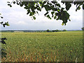
Farmland off Broxhill Road, Havering-atte-Bower, Essex
Looking east towards Harold Hill.
Image: © John Winfield
Taken: 4 Jul 2005
0.16 miles
3
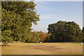
Bedfords Park
A pleasant afternoon for a picnic.
Image: © Trevor Harris
Taken: 27 Sep 2009
0.17 miles
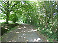
4
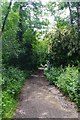
Bridleway 23 in Bedfords Park
The bridleway comes out on Image
Image: © Glyn Baker
Taken: 9 Jun 2020
0.18 miles
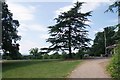
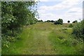
6
Old track in Bedfords Park
What is now Bedfords Park originated in the two adjoining estates of Bedfords, believed to be named after John Bedford, who held the land in 1362, and Earls, which later became known as Upper Bedfords. The lane which had run from Broxhill Road to Lower Bedfords Road and going past Bedfords was closed by the owner around 1777. This is still the main north-south route through the park although from Broxhill Road to the Visitor Centre it is a proper access road while to the south of this as far as Lower Bedfords Road it is no more than a path as seen here.
Bedfords was sold to Romford Urban District Council in 1933 who opened the park to the public in 1934, and instituted a museum in the house. During the Second World War Bedfords House was used by the Auxiliary Fire Service and afterwards was used as the Council archive but was gradually allowed to fall into disrepair until it was demolished in 1959. In the 1960s a cafe was built on the site of the house until this also fell out of use in the 1980s.
The site of the house is now occupied by a Visitor Centre run by Essex Wildlife Trust.
For a fuller history see https://en.wikipedia.org/wiki/Bedfords_Park and for a list of the facilities see http://www.essexwt.org.uk/reserves/bedfords-park
Image: © Marathon
Taken: 14 Jun 2017
0.20 miles
7
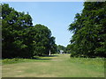
In Bedfords Park
What is now Bedfords Park originated in the two adjoining estates of Bedfords, believed to be named after John Bedford, who held the land in 1362, and Earls, which later became known as Upper Bedfords. The lane which had run from Broxhill Road to Lower Bedfords Road and going past Bedfords was closed by the owner around 1777. This is still the main north-south route through the park although from Broxhill Road to the Visitor Centre it is a proper access road while to the south of this as far as Lower Bedfords Road it is no more than a path.
Bedfords was sold to Romford Urban District Council in 1933 who opened the park to the public in 1934, and instituted a museum in the house. During the Second World War Bedfords House was used by the Auxiliary Fire Service and afterwards was used as the Council archive but was gradually allowed to fall into disrepair until it was demolished in 1959. In the 1960s a cafe was built on the site of the house until this also fell out of use in the 1980s.
The site of the house is now occupied by a Visitor Centre run by Essex Wildlife Trust and this can be seen in the distance here.
For a fuller history see https://en.wikipedia.org/wiki/Bedfords_Park and for a list of the facilities see http://www.essexwt.org.uk/reserves/bedfords-park
Image: © Marathon
Taken: 14 Jun 2017
0.20 miles
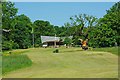
8
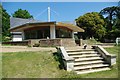
Bedfords Park Visitor Centre
This is the Essex Wildlife Trust visitor centre at Bedfords Park. The park has been owned by Havering Council since the 1930’s. The upper areas are managed as classic parkland. The lower areas are managed to attract wildlife. There is also a deer park go to Image to see one of the inmates. For more information on the wildlife side of the park see
http://www.essexwt.org.uk/visitor_centres__nature_reserves/bedfords_park/ For more pictures of Bedfords Park go to http://www.geograph.org.uk/search.php?i=30977034
Continue a virtual tour of Wildlife Trust Reserves in Essex
by visiting Image
Image: © Glyn Baker
Taken: 24 May 2009
0.21 miles
9
Bedfords Park
Looking towards the Essex Wildlife Trust visitor centre at Bedfords Park. The park has been owned by Havering Council since the 1930’s. The upper areas are managed as classic parkland. The lower areas are managed to attract wildlife. There is also a deer Park see Image &
Image to see one of the inmates. For more information on the wildlife side of the park see http://www.essexwt.org.uk/visitor_centres__nature_reserves/bedfords_park/
Image: © Glyn Baker
Taken: 24 May 2009
0.21 miles
10

Bedfords Park Panorama
This is the scene from outside Image looking down the hill towards South East London. To the right looking over the
Image can be seen the towers of canary wharf for more info see http://www.essexwt.org.uk/visitor_centres__nature_reserves/bedfords_park/
Image: © Glyn Baker
Taken: 24 May 2009
0.21 miles