IMAGES TAKEN NEAR TO
Church Lane, UPMINSTER, RM14 3TS
Introduction
This page details the photographs taken nearby to Church Lane, RM14 3TS by members of the Geograph project.
The Geograph project started in 2005 with the aim of publishing, organising and preserving representative images for every square kilometre of Great Britain, Ireland and the Isle of Man.

There are currently over 7.5m images from over14,400 individuals and you can help contribute to the project by visiting https://www.geograph.org.uk
Image Map
Images are licensed for reuse under creativecommons.org/licenses/by-sa/2.0
Notes
- Clicking on the map will re-center to the selected point.
- The higher the marker number, the further away the image location is from the centre of the postcode.
Image Listing (3 Images Found)
Images are licensed for reuse under creativecommons.org/licenses/by-sa/2.0
Image
Details
Distance
2
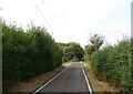
Church Lane heading south
Towards Kings Farm.
Image: © JThomas
Taken: 23 Aug 2022
0.17 miles
3
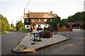
Bulphan and Flower Box
This is the Junction of Church Lane and The Elms Farm Drive. I suspect Bulphan is
in competition with Orsett in the "Britain in boom" contest!
Image: © Glyn Baker
Taken: 26 Jun 2010
0.18 miles