IMAGES TAKEN NEAR TO
St. Marys Lane, UPMINSTER, RM14 3NX
Introduction
This page details the photographs taken nearby to St. Marys Lane, RM14 3NX by members of the Geograph project.
The Geograph project started in 2005 with the aim of publishing, organising and preserving representative images for every square kilometre of Great Britain, Ireland and the Isle of Man.

There are currently over 7.5m images from over14,400 individuals and you can help contribute to the project by visiting https://www.geograph.org.uk
Image Map (Loading...)


Getting Data...Please wait
Leaflet Map data © OpenStreetMap
Images are licensed for reuse under creativecommons.org/licenses/by-sa/2.0
Notes
- Clicking on the map will re-center to the selected point.
- The higher the marker number, the further away the image location is from the centre of the postcode.
Image Listing (24 Images Found)
Images are licensed for reuse under creativecommons.org/licenses/by-sa/2.0
Image
Details
Distance
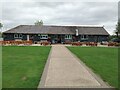
1
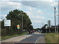
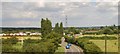
St. Mary's Lane, near Cranham
St. Mary's Lane at its junction with Clay Tye Road. The junction is a mini-roundabout.
Image: © Malc McDonald
Taken: 27 Aug 2017
0.04 miles
2
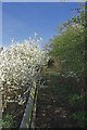
Footpath from Puddle Dock
This footpath starts at Puddle Dock then meets the footpath from Warley St to Cranham north of the railway line.
Image: © Glyn Baker
Taken: 10 Apr 2010
0.06 miles
3
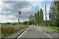
Wyngray Farm bus stop
Served by route 347 from Ockendon station to Romford station.
Image: © Robin Webster
Taken: 18 Sep 2011
0.06 miles
4
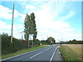
St. Mary's Lane, near Cranham
St. Mary's Lane, looking east. Despite the rural nature of this location, it lies within Greater London.
Image: © Malc McDonald
Taken: 27 Aug 2017
0.07 miles
6
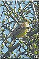
Yellowhammer
I am informed by a much better ornithologist than me that this is a male Yellowhammer (Emberiza citrinella); it was among the bushes on the Image
Image: © Glyn Baker
Taken: 10 Apr 2010
0.07 miles
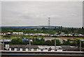
10
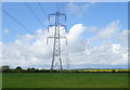
Farmland and power lines, Puddle Dock
Off the A186.
Image: © JThomas
Taken: 11 May 2019
0.14 miles