IMAGES TAKEN NEAR TO
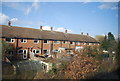
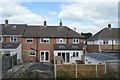
Peterborough Avenue, UPMINSTER, RM14 3LJ
Introduction
This page details the photographs taken nearby to Peterborough Avenue, RM14 3LJ by members of the Geograph project.
The Geograph project started in 2005 with the aim of publishing, organising and preserving representative images for every square kilometre of Great Britain, Ireland and the Isle of Man.

There are currently over 7.5m images from over14,400 individuals and you can help contribute to the project by visiting https://www.geograph.org.uk
Image Map
Images are licensed for reuse under creativecommons.org/licenses/by-sa/2.0
Notes
- Clicking on the map will re-center to the selected point.
- The higher the marker number, the further away the image location is from the centre of the postcode.
Image Listing (31 Images Found)
Images are licensed for reuse under creativecommons.org/licenses/by-sa/2.0
Image
Details
Distance
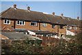
2
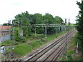
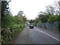
The C2C line seen from Front Lane bridge
The line between London and Tilbury was opened on 13th April 1854 by the London Tilbury & Southend Railway (LTSR) on their new line to Tilbury, which split from the Eastern Counties Railway (ECR) at Forest Gate. The London, Tilbury & Southend Railway (LTSR) direct line from Bow to Barking (avoiding Stratford and Forest Gate) was constructed from west to east in 1858. The route to Southend, however, was not direct, taking a considerable diversion from Barking via Dagenham Dock to serve the port at Tilbury. Between 1885 and 1888 a new direct route from Barking to Pitsea was constructed, and the line here east of Upminster opened on 1st May 1886. This is now the C2C line. This view is from the bridge carrying Front Lane over the railway.
Image: © Marathon
Taken: 24 May 2017
0.09 miles
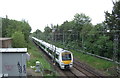
3
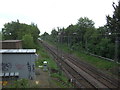
Railway towards Basildon
Looking north east from the bridge on Front Lane, Upminster.
Image: © JThomas
Taken: 11 May 2019
0.10 miles
4
Railway towards Basildon
Looking north east from the bridge on Front Lane, Upminster.
Image: © JThomas
Taken: 11 May 2019
0.10 miles
8
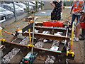
London Underground track
At the very front of the depot was a labelled real-life diagram of the four-rail track configuration used on the London Underground network. The leftmost rail and penultimate rail on the right are the running rails whilst the penultimate rail from the left and rightmost rail are the positive and negative supply rails, where the electrical current from the underside of the train feeds into and powers the train along. View taken looking east-southeast, with the bus stand and car park in the background.
Image: © Robert Lamb
Taken: 30 Aug 2009
0.16 miles
9
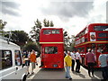
An RLH bus
Notice that the upper-deck emergency exit window of this RLH double-decker is divided unlike that of the Routemaster to the right of it. There is also no facility for a rear destination blind; this was because the RLH-class was not originally intended for London Transport. But the RLHs did carry rear number stencils in the rear lower-deck window. View taken looking south.
Image: © Robert Lamb
Taken: 30 Aug 2009
0.17 miles
10
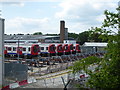
Upminster District line depot
Upminster depot, which serves the District line, was built between 1956 and 1958 and opened in 1959. It was the first depot to be built after the Second World War. It is situated beyond Upminster station which is the eastern limit of the District line and is to the north of the line to Basildon and Southend. This view is from Front Lane.
Image: © Marathon
Taken: 24 May 2017
0.18 miles