IMAGES TAKEN NEAR TO
Canterbury Avenue, UPMINSTER, RM14 3LD
Introduction
This page details the photographs taken nearby to Canterbury Avenue, RM14 3LD by members of the Geograph project.
The Geograph project started in 2005 with the aim of publishing, organising and preserving representative images for every square kilometre of Great Britain, Ireland and the Isle of Man.

There are currently over 7.5m images from over14,400 individuals and you can help contribute to the project by visiting https://www.geograph.org.uk
Image Map (Loading...)


Getting Data...Please wait
Leaflet Map data © OpenStreetMap
Images are licensed for reuse under creativecommons.org/licenses/by-sa/2.0
Notes
- Clicking on the map will re-center to the selected point.
- The higher the marker number, the further away the image location is from the centre of the postcode.
Image Listing (24 Images Found)
Images are licensed for reuse under creativecommons.org/licenses/by-sa/2.0
Image
Details
Distance
1
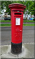
George V postbox on Lichfield Terrace, Upminster
Postbox No. RM14 361.
See Image] for context.
Image: © JThomas
Taken: 11 May 2019
0.10 miles
2
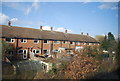
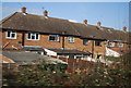
Houses on Lichfield Terrace, Upminster
Showing position of Postbox No. RM14 361.
See Image] for postbox.
Image: © JThomas
Taken: 11 May 2019
0.10 miles
3

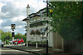
Sign for the Jobber's Rest Pub Brasserie, Upminster
See Image] for context.
Image: © JThomas
Taken: 11 May 2019
0.12 miles
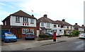
4
The Jobber's Rest Pub Brasserie, Upminster
On St Mary's Lane (B187).
Image: © JThomas
Taken: 11 May 2019
0.13 miles
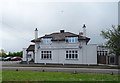
5
The Jobbers Rest
One of two pubs in a short distance along St Mary's Lane. The other is the Thatched House (it isn't), both seem well patronised.
Image: © Robin Webster
Taken: 18 Sep 2011
0.13 miles
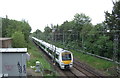
7
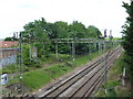
The C2C line seen from Front Lane bridge
The line between London and Tilbury was opened on 13th April 1854 by the London Tilbury & Southend Railway (LTSR) on their new line to Tilbury, which split from the Eastern Counties Railway (ECR) at Forest Gate. The London, Tilbury & Southend Railway (LTSR) direct line from Bow to Barking (avoiding Stratford and Forest Gate) was constructed from west to east in 1858. The route to Southend, however, was not direct, taking a considerable diversion from Barking via Dagenham Dock to serve the port at Tilbury. Between 1885 and 1888 a new direct route from Barking to Pitsea was constructed, and the line here east of Upminster opened on 1st May 1886. This is now the C2C line. This view is from the bridge carrying Front Lane over the railway.
Image: © Marathon
Taken: 24 May 2017
0.16 miles
8
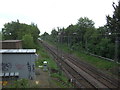
Railway towards Basildon
Looking north east from the bridge on Front Lane, Upminster.
Image: © JThomas
Taken: 11 May 2019
0.16 miles
9
Railway towards Basildon
Looking north east from the bridge on Front Lane, Upminster.
Image: © JThomas
Taken: 11 May 2019
0.16 miles