IMAGES TAKEN NEAR TO
Lichfield Terrace, UPMINSTER, RM14 3JD
Introduction
This page details the photographs taken nearby to Lichfield Terrace, RM14 3JD by members of the Geograph project.
The Geograph project started in 2005 with the aim of publishing, organising and preserving representative images for every square kilometre of Great Britain, Ireland and the Isle of Man.

There are currently over 7.5m images from over14,400 individuals and you can help contribute to the project by visiting https://www.geograph.org.uk
Image Map
Images are licensed for reuse under creativecommons.org/licenses/by-sa/2.0
Notes
- Clicking on the map will re-center to the selected point.
- The higher the marker number, the further away the image location is from the centre of the postcode.
Image Listing (28 Images Found)
Images are licensed for reuse under creativecommons.org/licenses/by-sa/2.0
Image
Details
Distance
1
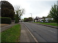
St. Marys Lane, Upminster
Looking east on the B187.
Image: © JThomas
Taken: 11 May 2019
0.03 miles
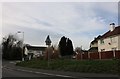
4
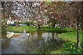
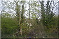
Pond in Cranham
The road in the background is called Pond Walk which is off of front Lane Cranham
Image: © Glyn Baker
Taken: 10 Apr 2010
0.10 miles
5
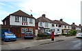
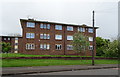
Houses on Lichfield Terrace, Upminster
Showing position of Postbox No. RM14 361.
See Image] for postbox.
Image: © JThomas
Taken: 11 May 2019
0.10 miles
6
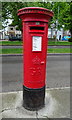
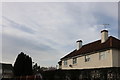
George V postbox on Lichfield Terrace, Upminster
Postbox No. RM14 361.
See Image] for context.
Image: © JThomas
Taken: 11 May 2019
0.10 miles
7
St Mary's Lane at the junction of Front Lane
Image: © David Howard
Taken: 9 Mar 2019
0.11 miles
8
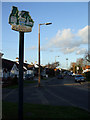
Cranham Village Sign
Looking along Front Lane.
Image: © terry joyce
Taken: 27 Jan 2012
0.11 miles
10
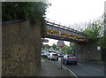
Railway bridge over St Mary's Lane (B187), Upminster
Image: © JThomas
Taken: 11 May 2019
0.11 miles