IMAGES TAKEN NEAR TO
Fieldwood Way, UPMINSTER, RM14 3EF
Introduction
This page details the photographs taken nearby to Fieldwood Way, RM14 3EF by members of the Geograph project.
The Geograph project started in 2005 with the aim of publishing, organising and preserving representative images for every square kilometre of Great Britain, Ireland and the Isle of Man.

There are currently over 7.5m images from over14,400 individuals and you can help contribute to the project by visiting https://www.geograph.org.uk
Image Map (Loading...)


Getting Data...Please wait
Leaflet Map data © OpenStreetMap
Images are licensed for reuse under creativecommons.org/licenses/by-sa/2.0
Notes
- Clicking on the map will re-center to the selected point.
- The higher the marker number, the further away the image location is from the centre of the postcode.
Image Listing (5 Images Found)
Images are licensed for reuse under creativecommons.org/licenses/by-sa/2.0
Image
Details
Distance
1
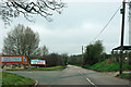
Entrance to Langdon Hills Golf Centre
As well as golf there is a Sunday carvery open to all and hotel rooms from £49.
Image: © Robin Webster
Taken: 25 Mar 2012
0.18 miles
2
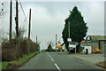
Lower Dunton Road at Little Malgraves
The road passes a hotch-potch collection of small businesses, ranging from kick-boxing and karate through lawn-mower repair's (sic) to designer flowers.
Image: © Robin Webster
Taken: 25 Mar 2012
0.23 miles
3
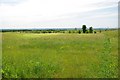
Langdon Hills Golf Course
I am afraid I couldn't find much original to photograph in this square! See http://www.golflangdon.co.uk/
Image: © Glyn Baker
Taken: 27 Jun 2010
0.24 miles
4
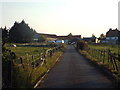
Farm driveway near Laindon
A driveway leading to farm buildings near Laindon in south Essex.
Image: © Malc McDonald
Taken: 27 Aug 2017
0.25 miles
5
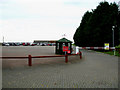
Langdon Hills Golf and Country Club
This is the security gate and car park at Langdon Hills Golf and Country Club.
Image: © terry joyce
Taken: 29 Oct 2010
0.25 miles