IMAGES TAKEN NEAR TO
St. Marys Lane, UPMINSTER, RM14 3DD
Introduction
This page details the photographs taken nearby to St. Marys Lane, RM14 3DD by members of the Geograph project.
The Geograph project started in 2005 with the aim of publishing, organising and preserving representative images for every square kilometre of Great Britain, Ireland and the Isle of Man.

There are currently over 7.5m images from over14,400 individuals and you can help contribute to the project by visiting https://www.geograph.org.uk
Image Map
Images are licensed for reuse under creativecommons.org/licenses/by-sa/2.0
Notes
- Clicking on the map will re-center to the selected point.
- The higher the marker number, the further away the image location is from the centre of the postcode.
Image Listing (42 Images Found)
Images are licensed for reuse under creativecommons.org/licenses/by-sa/2.0
Image
Details
Distance
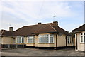
1
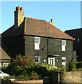
Early 19th century weatherboarded cottages
Located in St Mary's Lane, Upminster these Grade II listed buildings date to the early C19.
Image: © John Winfield
Taken: 3 Nov 2006
0.06 miles
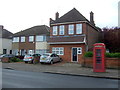
2
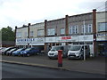
Shops on St Mary's Lane, Upminster
Showing position of Postbox No. RM14 384.
See Image] for postbox.
Image: © JThomas
Taken: 11 May 2019
0.06 miles
3
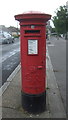
George V postbox on St Mary's Lane, Upminster
Postbox No. RM14 384.
See Image] for context.
Image: © JThomas
Taken: 11 May 2019
0.06 miles
4
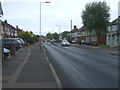
St Mary's Lane (B187), Upminster
Looking north east.
Image: © JThomas
Taken: 11 May 2019
0.08 miles
5
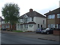
Funeral home on St Mary's Lane (B187), Upminster
Image: © JThomas
Taken: 11 May 2019
0.08 miles