IMAGES TAKEN NEAR TO
Church Road, UPMINSTER, RM14 3BJ
Introduction
This page details the photographs taken nearby to Church Road, RM14 3BJ by members of the Geograph project.
The Geograph project started in 2005 with the aim of publishing, organising and preserving representative images for every square kilometre of Great Britain, Ireland and the Isle of Man.

There are currently over 7.5m images from over14,400 individuals and you can help contribute to the project by visiting https://www.geograph.org.uk
Image Map
Images are licensed for reuse under creativecommons.org/licenses/by-sa/2.0
Notes
- Clicking on the map will re-center to the selected point.
- The higher the marker number, the further away the image location is from the centre of the postcode.
Image Listing (26 Images Found)
Images are licensed for reuse under creativecommons.org/licenses/by-sa/2.0
Image
Details
Distance
1
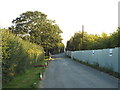
Brentwood Road, Bulphan
A view southwards along Brentwood Road in Bulphan.
The hoardings along the roadside protect a building site.
Image: © Malc McDonald
Taken: 27 Aug 2017
0.03 miles
2
Wick Place
Looking towards Image There was an old metalworking guillotine outside the outbuilding so I assume it was once a forge.
Image: © Glyn Baker
Taken: 27 Mar 2020
0.06 miles
3
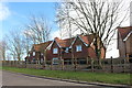
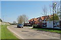
New houses on Church Road, Bulphan
This was a field up till recently
Image: © David Howard
Taken: 9 Mar 2019
0.06 miles
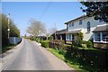
4
Church Road, Bulphan
Church Road in the village of Bulphan, in south Essex.
Image: © Malc McDonald
Taken: 27 Aug 2017
0.06 miles
5
Bonham Grange Bulphan
A new development of a "gated community".
Image: © Glyn Baker
Taken: 27 Mar 2020
0.07 miles
7
Bulphan's Green
This shot shows Bulphan's village green the farm implement in the picture is not a plough but a 1930's horse drawn potato lifter. It was placed on the green in June 2009 as part of the "Bulphan in Bloom Project" http://www.bulphancf.org.uk/Core/BulphanCf/Pages/Bulphan_in_Bloom_1.aspx
Image: © Glyn Baker
Taken: 7 Mar 2010
0.11 miles
8
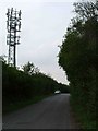
Wick Place Telecom's Tower
This telecom’s tower is located on the junction of the A128 and Wick Place.
Image: © Glyn Baker
Taken: 10 Sep 2005
0.13 miles
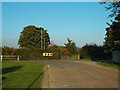
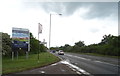
9
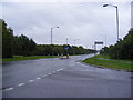
A128 Bulphan Bypass
Looking towards Orsett at the junction with Church Road
Image: © Geographer
Taken: 3 Oct 2010
0.13 miles
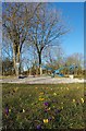
10
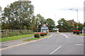
Village Entrance, Bulphan
Looking back along Church Road towards the Brentwood road junction. This year Bulphan won a Britain in Bloom award.
Image: © Trevor Harris
Taken: 19 Sep 2011
0.13 miles