IMAGES TAKEN NEAR TO
St. Marys Lane, UPMINSTER, RM14 2SH
Introduction
This page details the photographs taken nearby to St. Marys Lane, RM14 2SH by members of the Geograph project.
The Geograph project started in 2005 with the aim of publishing, organising and preserving representative images for every square kilometre of Great Britain, Ireland and the Isle of Man.

There are currently over 7.5m images from over14,400 individuals and you can help contribute to the project by visiting https://www.geograph.org.uk
Image Map
Images are licensed for reuse under creativecommons.org/licenses/by-sa/2.0
Notes
- Clicking on the map will re-center to the selected point.
- The higher the marker number, the further away the image location is from the centre of the postcode.
Image Listing (172 Images Found)
Images are licensed for reuse under creativecommons.org/licenses/by-sa/2.0
Image
Details
Distance
1
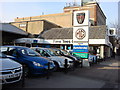
Time Tees Cars
A Car sales building on Station Road
Image: © Oxyman
Taken: 20 Mar 2009
0.04 miles
2
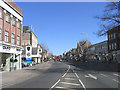
Station Road, Upminster
Looking north from Bell Corner
Image: © John Winfield
Taken: 5 Apr 2006
0.04 miles
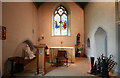
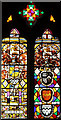
5
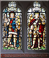
St Laurence, Upminster - Stained glass window
St George & St Michael
Image: © John Salmon
Taken: 31 May 2011
0.05 miles
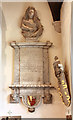
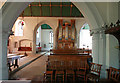
10
St Laurence, Upminster - Stained glass window
Image: © John Salmon
Taken: 31 May 2011
0.06 miles