IMAGES TAKEN NEAR TO
Norfolk Road, UPMINSTER, RM14 2RE
Introduction
This page details the photographs taken nearby to Norfolk Road, RM14 2RE by members of the Geograph project.
The Geograph project started in 2005 with the aim of publishing, organising and preserving representative images for every square kilometre of Great Britain, Ireland and the Isle of Man.

There are currently over 7.5m images from over14,400 individuals and you can help contribute to the project by visiting https://www.geograph.org.uk
Image Map
Images are licensed for reuse under creativecommons.org/licenses/by-sa/2.0
Notes
- Clicking on the map will re-center to the selected point.
- The higher the marker number, the further away the image location is from the centre of the postcode.
Image Listing (61 Images Found)
Images are licensed for reuse under creativecommons.org/licenses/by-sa/2.0
Image
Details
Distance
1
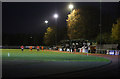
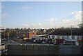
West Stand at The Bridge Avenue Stadium
The West Stand as seen from the north end of the ground during a match between Hornchurch and Wingate & Finchley. The Urchins (Hornchurch) in the red and white striped shirts ran out 3-0 winners over the visitors.
Image: © Martin Addison
Taken: 30 Nov 2013
0.03 miles
2
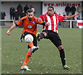
Challenging For The Ball
Wingate & Finchley and Hornchurch players challenge for the ball. The player on the right is in 'The Urchins' home strip of red and white striped shirt and black shorts. The Wingate & Finchley player is wearing the 2013/14 away strip of orange shirt and black shorts. The home side won the game 3-0.
Image: © Martin Addison
Taken: 30 Nov 2013
0.05 miles
3
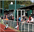
Bridge Avenue Stadium
Football fans enjoy a match between Hornchurch FC and Wingate & Finchley FC on a glorious autumn afternoon. Hornchurch FC are known as The Urchins.
Image: © Martin Addison
Taken: 1 Oct 2011
0.08 miles
4
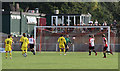
Football at Bridge Avenue Stadium
Wingate & Finchley FC, in yellow, play away against Hornchurch FC. Behind the goal, spectators take advantage of a glorious autumn day to sit and enjoy a beer in the garden of the bar complex. The bar is housed in the green building behind.
Image: © Martin Addison
Taken: 1 Oct 2011
0.09 miles
6
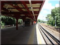
Upminster Bridge tube station, Westbound platform
Image: © Oxyman
Taken: 4 Jul 2008
0.12 miles
7
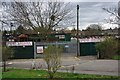
Hornchurch Stadium
Hornchurch Stadium http://www.runtrackdir.com/details.asp?track=hornchurch is home to Hornchurch AFC http://www.afchornchurch.com/ and Havering Mayesbrook Athletic Club http://www.havering-mayesbrook.org/
Image: © Glyn Baker
Taken: 2 Apr 2010
0.12 miles
9
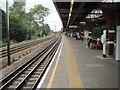
Upminster Bridge Underground station, Greater London
Opened in 1934 by the London Midland & Scottish Railway on the line from London to Upminster, this station transferred from British Rail to London Transport in 1969.
View south west towards Hornchurch and London. Like 55% of the London Underground network, this part is actually overground.
Image: © Nigel Thompson
Taken: 24 Sep 2015
0.12 miles
10
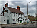
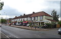
Upminster Bridge : "The Windmill" public house
Image: © Jim Osley
Taken: 6 Mar 2019
0.13 miles