IMAGES TAKEN NEAR TO
Hill Rise, UPMINSTER, RM14 2RA
Introduction
This page details the photographs taken nearby to Hill Rise, RM14 2RA by members of the Geograph project.
The Geograph project started in 2005 with the aim of publishing, organising and preserving representative images for every square kilometre of Great Britain, Ireland and the Isle of Man.

There are currently over 7.5m images from over14,400 individuals and you can help contribute to the project by visiting https://www.geograph.org.uk
Image Map
Images are licensed for reuse under creativecommons.org/licenses/by-sa/2.0
Notes
- Clicking on the map will re-center to the selected point.
- The higher the marker number, the further away the image location is from the centre of the postcode.
Image Listing (87 Images Found)
Images are licensed for reuse under creativecommons.org/licenses/by-sa/2.0
Image
Details
Distance
5
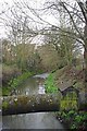
Ingrebourne in Upminster
A strange place for a duck house but it would provide a challenge for urban foxes
Image: © Glyn Baker
Taken: 2 Apr 2010
0.07 miles
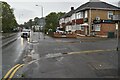
8
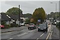
Upminster Road, Upminster
Looking south east on the A124.
Image: © JThomas
Taken: 11 May 2019
0.08 miles