IMAGES TAKEN NEAR TO
St. Marys Lane, UPMINSTER, RM14 2QR
Introduction
This page details the photographs taken nearby to St. Marys Lane, RM14 2QR by members of the Geograph project.
The Geograph project started in 2005 with the aim of publishing, organising and preserving representative images for every square kilometre of Great Britain, Ireland and the Isle of Man.

There are currently over 7.5m images from over14,400 individuals and you can help contribute to the project by visiting https://www.geograph.org.uk
Image Map
Images are licensed for reuse under creativecommons.org/licenses/by-sa/2.0
Notes
- Clicking on the map will re-center to the selected point.
- The higher the marker number, the further away the image location is from the centre of the postcode.
Image Listing (114 Images Found)
Images are licensed for reuse under creativecommons.org/licenses/by-sa/2.0
Image
Details
Distance
1
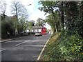
Saint Mary's Lane Upminster
Looking West along St. Mary's Lane Upminster from the entrance of the Upminster Windmill.
Image: © Richard Dunn
Taken: 10 Oct 2011
0.02 miles
2
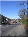
St Marys Lane, Upminster
A view to the west from opposite Upminster Windmill.
Image: © John Winfield
Taken: 5 Apr 2006
0.03 miles
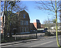
3
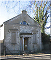
Upminster Old Chapel, Upminster
The chapel, built in 1800 is a Grade II listed building and in a rather sorry state of repair. It is located on south side of St Marys Lane by Sacred Heart School.
Image: © John Winfield
Taken: 5 Apr 2006
0.03 miles
4
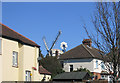
A windmill in the garden!
The top of Upminster Windmill glimpsed over the roofs of nearby houses.
Image: © John Winfield
Taken: 5 Apr 2006
0.04 miles
5
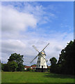
Upminster Windmill, Upminster, Essex
A fine example of a "Smock" windmill built in 1803.
Image: © John Winfield
Taken: 11 Jun 2005
0.07 miles
6
Sacred Heart School, Upminster
A catholic girls' school, located on south side of St Marys Lane.
Image: © John Winfield
Taken: 5 Apr 2006
0.07 miles
7
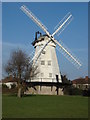
Upminster Windmill
Originally known as Abraham's Mill
More information at http://en.wikipedia.org/wiki/Upminster_Windmill
Image: © Oxyman
Taken: 20 Mar 2009
0.07 miles
8
New Windmill Hall, Upminster
Located on north side of Upminster Park, this council run complex is used for shows, exhibitions and local theatre groups.
Image: © John Winfield
Taken: 5 Apr 2006
0.07 miles
9
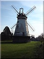
Upminster Windmill
Originally known as Abraham's Mill, this is a view of the Grade II* listed smock mill from the north.
More information at http://en.wikipedia.org/wiki/Upminster_Windmill
Image: © Oxyman
Taken: 20 Mar 2009
0.08 miles
10
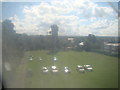
View over London from Upminster Windmill
This was taken through one of the perspex windows of the windmill, so apologies for the poor image quality here. There is a much clearer view to follow though! Looking south-southwest.
Image: © Robert Lamb
Taken: 7 Sep 2013
0.08 miles