IMAGES TAKEN NEAR TO
Hornbeam Avenue, UPMINSTER, RM14 2NH
Introduction
This page details the photographs taken nearby to Hornbeam Avenue, RM14 2NH by members of the Geograph project.
The Geograph project started in 2005 with the aim of publishing, organising and preserving representative images for every square kilometre of Great Britain, Ireland and the Isle of Man.

There are currently over 7.5m images from over14,400 individuals and you can help contribute to the project by visiting https://www.geograph.org.uk
Image Map
Images are licensed for reuse under creativecommons.org/licenses/by-sa/2.0
Notes
- Clicking on the map will re-center to the selected point.
- The higher the marker number, the further away the image location is from the centre of the postcode.
Image Listing (42 Images Found)
Images are licensed for reuse under creativecommons.org/licenses/by-sa/2.0
Image
Details
Distance
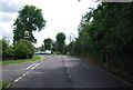
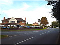
1
Alder Avenue, near Upminster
Alder Avenue is a residential road on the outer fringes of east London.
Image: © Malc McDonald
Taken: 28 Aug 2017
0.07 miles
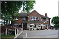
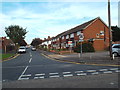
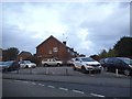
5
Optimist Tavern, near Upminster
The Optimist Tavern, on the outer fringe of east london.
Image: © Malc McDonald
Taken: 28 Aug 2017
0.08 miles
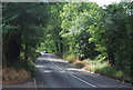
9
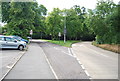
Junction off Gaynes Park Rd and Hacton Lane
Image: © N Chadwick
Taken: 18 Jun 2011
0.10 miles