IMAGES TAKEN NEAR TO
Southview Drive, UPMINSTER, RM14 2LD
Introduction
This page details the photographs taken nearby to Southview Drive, RM14 2LD by members of the Geograph project.
The Geograph project started in 2005 with the aim of publishing, organising and preserving representative images for every square kilometre of Great Britain, Ireland and the Isle of Man.

There are currently over 7.5m images from over14,400 individuals and you can help contribute to the project by visiting https://www.geograph.org.uk
Image Map
Images are licensed for reuse under creativecommons.org/licenses/by-sa/2.0
Notes
- Clicking on the map will re-center to the selected point.
- The higher the marker number, the further away the image location is from the centre of the postcode.
Image Listing (9 Images Found)
Images are licensed for reuse under creativecommons.org/licenses/by-sa/2.0
Image
Details
Distance
1
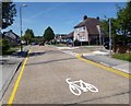
White Line Bicycle
These are painted on the road all along here, with two side by side at the end.
Brookdale Close, Upminster.
Image: © Des Blenkinsopp
Taken: 4 Jun 2013
0.20 miles

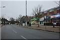
8
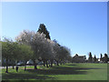
Upminster Park, Upminster
Looking south with Corbets Tey Road on left side of picture
Image: © John Winfield
Taken: 5 Apr 2006
0.25 miles
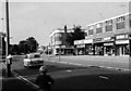
9
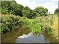
Ingrebourne River in Upminster
The Ingrebourne rises near Brentwood and flows into the Thames at Rainham, a distance of about 27 miles or about 43 kilometres.
Image: © Nigel Cox
Taken: 28 Jul 2010
0.25 miles