IMAGES TAKEN NEAR TO
Gaynes Park Road, UPMINSTER, RM14 2HX
Introduction
This page details the photographs taken nearby to Gaynes Park Road, RM14 2HX by members of the Geograph project.
The Geograph project started in 2005 with the aim of publishing, organising and preserving representative images for every square kilometre of Great Britain, Ireland and the Isle of Man.

There are currently over 7.5m images from over14,400 individuals and you can help contribute to the project by visiting https://www.geograph.org.uk
Image Map
Images are licensed for reuse under creativecommons.org/licenses/by-sa/2.0
Notes
- Clicking on the map will re-center to the selected point.
- The higher the marker number, the further away the image location is from the centre of the postcode.
Image Listing (29 Images Found)
Images are licensed for reuse under creativecommons.org/licenses/by-sa/2.0
Image
Details
Distance
1
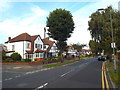
Little Gaynes Lane, near Upminster
Little Gaynes Lane is a tree-lined residential road in east London's outermost suburbs.
Image: © Malc McDonald
Taken: 28 Aug 2017
0.04 miles

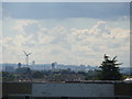
4
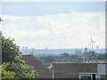
View over London from Upminster Windmill #2
The Crystal Palace transmitter can be seen on the hill to the left and one of the wind turbines at Dagenham Ford can be seen on the right. Looking south-southwest.
Image: © Robert Lamb
Taken: 7 Sep 2013
0.17 miles
5
View of Dagenham Ford from Upminster Windmill
Looking south-southwest.
Image: © Robert Lamb
Taken: 7 Sep 2013
0.18 miles
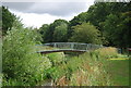
7
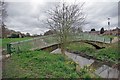
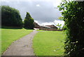
Ingrebourne Span
This footbridge provides a convenient short cut between Derry Ave & Gaynes Park Road
Image: © Glyn Baker
Taken: 2 Apr 2010
0.18 miles
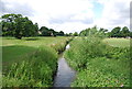
9
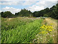
Ingrebourne River in Upminster
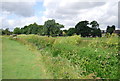
The reed-choked Ingrebourne just clips the north-western corner of this grid square. A large growth of the invasive Himalayan Balsam (impatiens glandulifera) is visible on the bank to the left, with ragwort to the right.
Image: © Nigel Cox
Taken: 28 Jul 2010
0.18 miles