IMAGES TAKEN NEAR TO
Beech Avenue, UPMINSTER, RM14 2HW
Introduction
This page details the photographs taken nearby to Beech Avenue, RM14 2HW by members of the Geograph project.
The Geograph project started in 2005 with the aim of publishing, organising and preserving representative images for every square kilometre of Great Britain, Ireland and the Isle of Man.

There are currently over 7.5m images from over14,400 individuals and you can help contribute to the project by visiting https://www.geograph.org.uk
Image Map
Images are licensed for reuse under creativecommons.org/licenses/by-sa/2.0
Notes
- Clicking on the map will re-center to the selected point.
- The higher the marker number, the further away the image location is from the centre of the postcode.
Image Listing (13 Images Found)
Images are licensed for reuse under creativecommons.org/licenses/by-sa/2.0
Image
Details
Distance

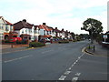
8
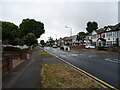
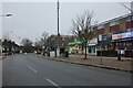
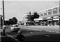
Corbets Tey Road, near Upminster
Corbets Tey Road, in east London's outermost suburbs.
Image: © Malc McDonald
Taken: 28 Aug 2017
0.19 miles
9
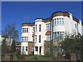
Springfield Court, Upminster
A good example of 1930's 'Art Deco' flats located in Springfield Gardens
Image: © John Winfield
Taken: 5 Apr 2006
0.20 miles
10
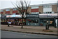
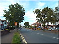
Corbets Tey Road, near Upminster
Corbets Tey Road, on the outer fringes of east London.
Image: © Malc McDonald
Taken: 28 Aug 2017
0.21 miles