IMAGES TAKEN NEAR TO
Pine Court, UPMINSTER, RM14 2HT
Introduction
This page details the photographs taken nearby to Pine Court, RM14 2HT by members of the Geograph project.
The Geograph project started in 2005 with the aim of publishing, organising and preserving representative images for every square kilometre of Great Britain, Ireland and the Isle of Man.

There are currently over 7.5m images from over14,400 individuals and you can help contribute to the project by visiting https://www.geograph.org.uk
Image Map (Loading...)


Getting Data...Please wait
Leaflet Map data © OpenStreetMap
Images are licensed for reuse under creativecommons.org/licenses/by-sa/2.0
Notes
- Clicking on the map will re-center to the selected point.
- The higher the marker number, the further away the image location is from the centre of the postcode.
Image Listing (13 Images Found)
Images are licensed for reuse under creativecommons.org/licenses/by-sa/2.0
Image
Details
Distance
1
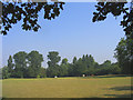
Parklands Wood, Upminster, Essex
This is a thin strip of woodland extending west from Corbets Tey Road, but with a wide range of native species. The field in front is used as grazing by a riding stables.
Image: © John Winfield
Taken: 13 Aug 2005
0.15 miles

3
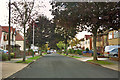
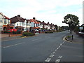
Little Gaynes Lane, near Upminster
Little Gaynes Lane is a tree-lined residential road in east London's outermost suburbs.
Image: © Malc McDonald
Taken: 28 Aug 2017
0.17 miles
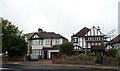
4
Tawny Avenue, Upminster
A product of the suburban spread of Upminster over the parkland of Gaynes Park between the wars. It was a slow development, even up to at least 1950 there were many plots not built on, and the road was unmade*. Oddly, on the first Ordnance Survey large scale map to show the road, it was called 'Dawns Avenue' - a misread developer's plan?
* I know because I was there!
Image: © Robin Webster
Taken: 18 Sep 2011
0.19 miles
5
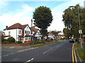
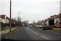
Corbets Tey Road, near Upminster
Corbets Tey Road, in east London's outermost suburbs.
Image: © Malc McDonald
Taken: 28 Aug 2017
0.22 miles
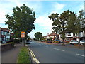
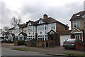
6
Corbets Tey Road, near Upminster
Corbets Tey Road, on the outer fringes of east London.
Image: © Malc McDonald
Taken: 28 Aug 2017
0.22 miles
10
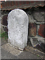
Old Milestone by the B1421, Corbets Tey Road, Upminster
Carved stone post by the B1421, in parish of Upminster (Havering District), in front of No.217 Corbets Tey Road, by wall, on East side of road. Erected by an unknown authority in the 19th century.
Inscription not known.
Milestone Society National ID: EX_RDGR16
Image: © JV Nicholls
Taken: 27 Feb 2011
0.24 miles