IMAGES TAKEN NEAR TO
Sunnings Lane, UPMINSTER, RM14 2DG
Introduction
This page details the photographs taken nearby to Sunnings Lane, RM14 2DG by members of the Geograph project.
The Geograph project started in 2005 with the aim of publishing, organising and preserving representative images for every square kilometre of Great Britain, Ireland and the Isle of Man.

There are currently over 7.5m images from over14,400 individuals and you can help contribute to the project by visiting https://www.geograph.org.uk
Image Map
Images are licensed for reuse under creativecommons.org/licenses/by-sa/2.0
Notes
- Clicking on the map will re-center to the selected point.
- The higher the marker number, the further away the image location is from the centre of the postcode.
Image Listing (19 Images Found)
Images are licensed for reuse under creativecommons.org/licenses/by-sa/2.0
Image
Details
Distance
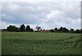
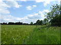
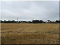
3
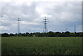
Pylons by Sunning Lane
Seen across a wheat field from Ockendon Rd.
Image: © N Chadwick
Taken: 18 Jun 2011
0.10 miles
4
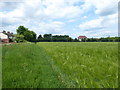
Footpath next to Sunnings Lane
Although the Ordnance Map shows the footpath going diagonally across this field to reach Ockenden Road at the junction with Stubbers Lane, in actuality it stuck close to Sunnings Lane which is just the other side of the hedge on the right.
Image: © Marathon
Taken: 24 May 2017
0.12 miles
5
Footpath next to Sunnings Lane
Although the Ordnance Map shows the footpath going diagonally across this field to reach Ockenden Road at the junction with Stubbers Lane, in actuality it stuck close to Sunnings Lane. The houses on the left are in Sunnings Lane while the house right of centre is on Ockenden Road.
Image: © Marathon
Taken: 24 May 2017
0.14 miles
6
Oilseed Rape field
The crop has gone to seed.
Image: © N Chadwick
Taken: 18 Jun 2011
0.15 miles
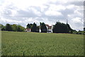
7
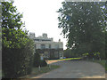
Harwood Hall, Corbets Tey, Upminster
This elegant country house was built in 1782 for George Stubbs. It is now used as a 'Montessori' School.
Image: © John Winfield
Taken: 13 Aug 2005
0.16 miles
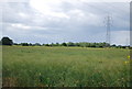
9
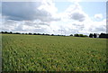
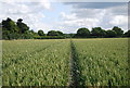
Spot the path
There is a public right of way across this field, somewhere.
Image: © N Chadwick
Taken: 18 Jun 2011
0.18 miles