IMAGES TAKEN NEAR TO
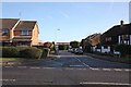
Dorkins Way, UPMINSTER, RM14 1XX
Introduction
This page details the photographs taken nearby to Dorkins Way, RM14 1XX by members of the Geograph project.
The Geograph project started in 2005 with the aim of publishing, organising and preserving representative images for every square kilometre of Great Britain, Ireland and the Isle of Man.

There are currently over 7.5m images from over14,400 individuals and you can help contribute to the project by visiting https://www.geograph.org.uk
Image Map
Images are licensed for reuse under creativecommons.org/licenses/by-sa/2.0
Notes
- Clicking on the map will re-center to the selected point.
- The higher the marker number, the further away the image location is from the centre of the postcode.
Image Listing (30 Images Found)
Images are licensed for reuse under creativecommons.org/licenses/by-sa/2.0
Image
Details
Distance
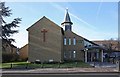
2
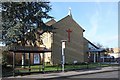
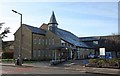
St Luke's Church, Front Lane, Cranham, Essex
Image: © John Salmon
Taken: 21 Jan 2009
0.17 miles
3
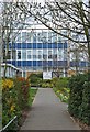
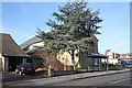
Hall Mead School
The main entrance to Hall mead School http://www.sch.hallmeadschool.co.uk/
Image: © Glyn Baker
Taken: 10 Apr 2010
0.17 miles
4
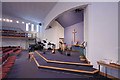
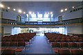
St Luke's Church, Front lane, Cranham, Essex - Chancel
Image: © John Salmon
Taken: 21 Jan 2009
0.18 miles
5
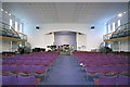
St Luke's Church, Front lane, Cranham, Essex - East end
Image: © John Salmon
Taken: 21 Jan 2009
0.18 miles
6
St Luke's Church, Front lane, Cranham, Essex - West end
Image: © John Salmon
Taken: 21 Jan 2009
0.19 miles
7
St Luke's Church, Front Lane, Cranham, Essex
Image: © John Salmon
Taken: 21 Jan 2009
0.19 miles
8
St Luke's Church, Front lane, Cranham, Essex
Image: © John Salmon
Taken: 21 Jan 2009
0.19 miles
9
St Luke's Church, Front lane, Cranham, Essex
Image: © John Salmon
Taken: 21 Jan 2009
0.19 miles
10
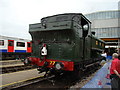
GWR Pannier Tank Engine (rear view)
This is a rear view of the Pannier Tank engine, looking west-southwest.
Image: © Robert Lamb
Taken: 30 Aug 2009
0.20 miles