IMAGES TAKEN NEAR TO
Waldegrave Gardens, UPMINSTER, RM14 1UX
Introduction
This page details the photographs taken nearby to Waldegrave Gardens, RM14 1UX by members of the Geograph project.
The Geograph project started in 2005 with the aim of publishing, organising and preserving representative images for every square kilometre of Great Britain, Ireland and the Isle of Man.

There are currently over 7.5m images from over14,400 individuals and you can help contribute to the project by visiting https://www.geograph.org.uk
Image Map
Images are licensed for reuse under creativecommons.org/licenses/by-sa/2.0
Notes
- Clicking on the map will re-center to the selected point.
- The higher the marker number, the further away the image location is from the centre of the postcode.
Image Listing (66 Images Found)
Images are licensed for reuse under creativecommons.org/licenses/by-sa/2.0
Image
Details
Distance
1
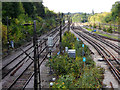
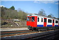
Railway tracks leading west from Upminster Station
The track on the extreme right is the single line branch to Emerson Park and Romford. The tracks just to the right of the shrubbery are the District Line of the London Underground to Dagenham, Barking and beyond. The tracks on the left are the C2C main line to Barking and Fenchurch Street.
Image: © Richard Dunn
Taken: 10 Oct 2011
0.10 miles
3
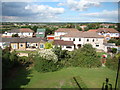
View North from the Mill
Looking NW from a window at the top of Upminster Mill.
Image: © Des Blenkinsopp
Taken: 4 Jun 2013
0.13 miles
5
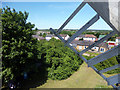
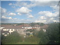
View over Upminster from the top floor of Upminster Windmill
Looking north-northeast.
Image: © Robert Lamb
Taken: 7 Sep 2013
0.15 miles
6
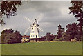
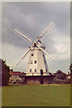
Upminster Windmill
Upminster windmill was built in 1803 by James Nokes, Upminster's smock mill continued in use until 1920s. After the death of Clement Abraham, in September 1935, his brothers and co-owners Thomas and Alfred offered it for sale. Essex County Council placed a preservation order on it in 1937, eventually acquiring the mill in 1940. thanks to a public appeal the mill was restored by 1950 but decayed again over the next decade. The adjoining mill buildings were demolished in 1960 but the mill received the necessary maintenance work a couple of years later, before passing to the London Borough of Havering in 1964.
http://www.upminster.com/history/places/windmill.htm
Image: © Christine Matthews
Taken: Unknown
0.16 miles
7
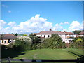
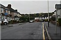
View of houses on Highview Gardens from Upminster Windmill
Looking north-northeast.
Image: © Robert Lamb
Taken: 7 Sep 2013
0.16 miles
8
View over Upminster from the top floor of Upminster Windmill #2
This was taken through one of the perspex windows of the windmill, which as you can see are quite dirty, so apologies for the poor image quality here! Looking north-northeast.
Image: © Robert Lamb
Taken: 7 Sep 2013
0.16 miles
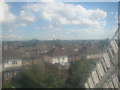
9
View over Upminster from the second floor of Upminster Windmill
Looking east-northeast. The road in the foreground is Highview Gardens.
Image: © Robert Lamb
Taken: 7 Sep 2013
0.16 miles
10
Upminster Windmill
Upminster windmill was built in 1803 by James Nokes, Upminster's smock mill continued in use until 1920s. After the death of Clement Abraham, in September 1935, his brothers and co-owners Thomas and Alfred offered it for sale. Essex County Council placed a preservation order on it in 1937, eventually acquiring the mill in 1940. thanks to a public appeal the mill was restored by 1950 but decayed again over the next decade. The adjoining mill buildings were demolished in 1960 but the mill received the necessary maintenance work a couple of years later, before passing to the London Borough of Havering in 1964.
http://www.upminster.com/history/places/windmill.htm
Image: © Christine Matthews
Taken: Unknown
0.17 miles